
User's Manual


56
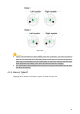
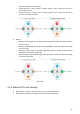
4.3.1.1 Waypoints
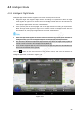
Select “Waypoints”. Step 1
The system displays “Waypoints” interface, as shown in Figure 4-12.
Check total route length, estimated flight time and set “Cycle Flight” at the bottom of the
interface.
Figure 4-12
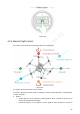
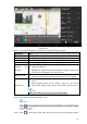
Click the map and the position can be set as a waypoint; several waypoints can be Step 2
connected together and form a route.
Check total route length, estimated flight time and set “Cycle Flight” at the bottom of the
interface.
Click a waypoint and it will become red. Waypoint setting interface will display on the
Step 3
right of the interface, as shown in Figure 4-13.