
Getting Started Guide


147
OMNISENSE
TM
ANALYSIS OPERATIONS
GPS Data (1/2)
Export GPS Data
Data which has been received or downloaded from a BioModule using a
supported GPS will show a sux of (GPS) in the Select Session tree, and
Export GPS Data to KML File will populate as a right-click context menu
option.
A KML (Keyhole Markup Language) le will open in Google Earth
TM
*
if installed.
OmniSense
TM
-generated .kml les also contain basic physiological data which
can be viewed in the context of satellite or map view.
Export and Open Location Data
1. Save the kml le to a preferred location, and click to open.
2. Google Earth
TM
*
(if installed) will open. All built-in viewing functionality is
available, and the .kml le will display in the Temporary Places node.
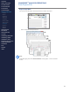
# Description
1 KML le in Temporary Places node.
2 Slider control to move place mark around trace
3 Path contained in kml le
4 Place mark showing current location according to slider control.
1
2
3
4
CONTENTS
ABOUT THIS MANUAL
GETTING STARTED
SYSTEM OVERVIEW
SYSTEM SETUP
LIVE OPERATIONS
ANALYSIS OPERATIONS
> Overview
> Sessions
> Subsessions
> Graph Types
> Time Graphs
> Summary Graphs
> Graph Functions
> Print / Export
> Data Filters
> GPS Data
> Readiness
ANALYSIS IMPACT
PROCESSING
ANALYSIS REPORTS
LOG DATA
OMNISENSE
TM
WEB PORTAL
OMNISENSE
TM
MOBILE
OMNISENSE
TM
TOOLS
BASELINE FITNESS TESTING
FITNESS PARAMETERS
APPENDICES
EULA
SUPPORT
INDEX