
Getting Started Guide


224
OMNISENSE
TM
WEB PORTAL
Reports (7/17)
Google
TM
*
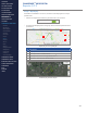
Map Display
If GPS data is available for a session, then data can be displayed on a map or
satellite view.
∙
Click on the map button below the parameter list to set to Show.
∙
A map panel will display below the graph, with a Snail Trail panel below the
parameters.
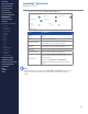
Map display, no terrain, partial path
# Description
1 Subject path snail trail (defaults to last 10 min of data)
2 Set map/terrain or satellite/labels
3 View map full screen or Google Street View
TM
*
4 Map zoom - also use Ctrl + Mouse scroll
Satellite display, no labels, full path
1
2
3
4
CONTENTS
ABOUT THIS MANUAL
GETTING STARTED
SYSTEM OVERVIEW
SYSTEM SETUP
LIVE OPERATIONS
ANALYSIS OPERATIONS
ANALYSIS IMPACT
PROCESSING
ANALYSIS REPORTS
LOG DATA
OMNISENSE
TM
WEB PORTAL
> Overview
> Home Screen
> Default Widgets
> Custom Widgets
> My Prole
> Live Screen
> Analysis
> Reports
> Calendar
> Devices
> Teams
> Athletes
> Manage User Roles
> Manage Users
> Training Plans
> Preferences
> Threshold Settings
OMNISENSE
TM
MOBILE
OMNISENSE
TM
TOOLS
BASELINE FITNESS TESTING
FITNESS PARAMETERS
APPENDICES
EULA
SUPPORT
INDEX