
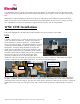
User's Guide

©WhereNet Corp. August 2007D1312r01 WhereTrack Users Guide 28September07.doc Page 4
Introduction
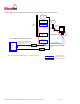
System overview
The WhereNet Real Time Locating System (RTLS) is designed to permit users to determine the position of tagged assets
in both indoor and outdoor facilities such as factories and freight yards. The system locates tagged assets by a process
involving redundant triangulation. Each tag autonomously emits a 2.4 GHz direct sequence spread spectrum (DSSS) radio
signal at predetermined blink rate. Each tag’s blink rate is randomized around its predetermined value to minimize the
number of collisions between transmissions made by different tags. The signal emitted by the tag is received by a
minimum of four Location Antennas. A typical transmission contains a preamble which is used to synchronize the
receiver, the tag’s serial number which identifies the tag, a status word which monitors various tag functions, data stored
in the tag’s memory and finally a CRC used to assure that the tag’s message is correct as received.
A WhereTrack or WNC unit may be utilized as part of the RTLS to locate yard vehicles, back haul GPS and telemetry
information from the CPE and also offers WiFi communication capability.
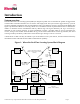
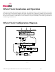
Figure 1: WhereNet Real Time Locating System Block Diagram
WhereTag IV
VSS Server
VSS
Database
1-Way 2.4 GHz DSSS or 802.11b
(Range = 1000 ft indoors or 3000 ft
outdoors)
WherePort
III
1-Way 115 kHz FSK
(Range = 25 ft)
WhereWand
Hand-held
Computer with
Laser Barcode
Reader
115 kHz
FSK
2.4 GHz
OOK
(Range = 3 ft)
1-Way
2.4 GHz
DSSS
WhereLan
WhereLan
WhereLan
WhereLan
Corporate LAN
Wired
Ethernet or
Wireless
802.11 Link
Wired
Ethernet or
Wireless
802.11 Link
WhereTrack
WNC
1-Way 2.4 GHz DSSS or 2 way
802.11b/g
(Range = 1000 ft outdoors)
GPS
CPE
Ethernet +
DC Power