WhereTrack - WNC User’s Guide Document Number D1312r01 Preliminary, August 2007 Model Number: WTK-5000-00AA WhereNet Corp. 2858 De La Cruz Blvd. Santa Clara, CA 95050 408-845-8500 WWW.WhereNet.COM ©WhereNet Corp. August 2007D1312r01 WhereTrack Users Guide 28September07.
FCC Requirements This device complies with Part 15 of the FCC Rules. Operation is subject to the following two conditions: (1) this device may not cause harmful interference, and (2) this device must accept any interference received, including interference that may cause undesired operation. See FCC registration label, located on the side of the equipment for the FCC, registration.
Contents Introduction ........................................................................................................................4 Installation and Operation ................................................................................................7 WNC Mounting Options....................................................................................................7 Specifications .........................................................................................................
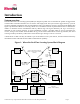
Introduction System overview The WhereNet Real Time Locating System (RTLS) is designed to permit users to determine the position of tagged assets in both indoor and outdoor facilities such as factories and freight yards. The system locates tagged assets by a process involving redundant triangulation. Each tag autonomously emits a 2.4 GHz direct sequence spread spectrum (DSSS) radio signal at predetermined blink rate.
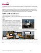
WhereTrack WNC Unit The WhereTrack is a custom WhereNet product that supports 802.11b/g WiFi, GPS, and the WhereNet Real Time Locating System (RTLS). It is a medium sized device that can be attached to a variety of CPE such as UTRs, RTGs, FELs, STs and SGs. A PACECO PTIU is generally, but not always, also installed on the CPE.
The WhereTrack complies with the ISO 24730-2 RTLS standard and IEEE 802.11b/g standards. It operates in the globally accepted 2.4GHz frequency band and transmits spread spectrum and WLAN signals in accordance with these standards. The use of direct sequence spread spectrum technology provides extremely long range; in excess of 1,000 meter locate range outdoors, and 300 meter locate range indoors.
WhereTrack Installation and Operation WNC units are shipped with all radio emitters deactivated. After installing a WNC to a vehicle to be tracked, the unit must be activated. This is done using the Ethernet cable serial connection from a computer to the WNC unit along with DC power. A computer can be used to configure and activate the internal tag functionality, 802.11b/g transceiver, and verify the GPS receiver function.
WNC Software Configuration The WNC unit can be configured by using a hyperterminal window on a laptop computer’s serial connection. Once DC power is applied to the WNC unit, it executes a software boot sequence which ends at the WNC main menu screen. From this menu, the WNC can change Ethernet or Serial settings, set health alerts, access diagnostics, upgrade the WNC firmware, and also control the embedded tag settings.
The GPS Master Station is critical to the operation of the GPS solution. It will consist of a pair of GPS units and will require the customer to provide DC power derived from redundant DC power supplies whose AC input is backed up by UPS. WhereNet has completed preliminary testing of the quality of UTR GPS locates in a Marine Terminal environment.
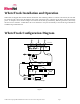
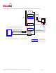
A block diagram of the components and connectivity of the Gen2 hardware is shown below.
RTG/Transtainer An RTG is a large CHE that can create large container stacks and deliver and receive container to and from UTRs and over-the-road trucks. RTGs vary from 50’ to 100’ in overall height, depending upon the make/model. Sample RTGs are shown in the following photos.
Buddy HO WT-III Top of RTG over Container Bay Site Variations per RTG model HD WPIII HD WPIII Health WTIII HD WP Bracket Right RTG Truck Lane Leg GPS L1 Antenna RTLS/WiFi Antenna Health WTIII Optional Compass HD WP Bracket Left RTG Truck Lane Leg RTLS/WiFi Antenna Mount GPS Antenna Mount Note 1 RTLS/WiFi Antenna Cable GPS Antenna Cable WNC Gen2 RTG Installation Block Flex Counduit Diagram PTIU Enclosure - Compass WNC Enclosure Flex Counduit Antenna - WNC Enclosure Compass RS422 cable PTIU
FEL A FEL is a large CHE that can create large container stacks and deliver and receive container to and from UTRs and overthe-road trucks. FELs vary greatly in design, depending upon the make/model. Some FELs are designed to pick up empty containers (‘Side Handlers’), and some are designed to pick up loaded containers (“Top Handlers”). Sample FELs are limited to stacks of containers up to 5-high, whereas others can work with 6-high and 7-high container stacks. Sample FELs are shown below.
HD WPIII Opt. Health WTIII Health WTIII HD WP Bracket Right Spreader End HD WPIII Opt.
SC and ST SCs and STs are CHE used by so called ‘straddle’ operators. Straddle container stacks are different than FEL/RTG stacks in that containers are not placed immediately adjacent to one another. They are stacked from 2-high or 3-high creating long rows of containers separated from each other by about 7’. An SC and an ST are shown in the following photo. SC ST Neither WhereNet nor PACECO have installed any equipment (yet) on an SC/ST. The installation, however, is expected to be straightforward.
WP on Legs Optional Solution Dependant Opt. Health WTIII Opt.
WP on Legs Optional Solution Dependant Opt. Health WTIII Opt.
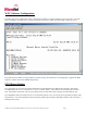
WNC Mounting Options The mounting of the WNC unit will depend on the specific application for the WNC. Please refer to the installation instructions for each particular application for specific instructions. Below is an outline drawing of the WNC that details the mounting hole locations. ©WhereNet Corp September 2006D1312r01 WhereTrack Users Guide 28September07.
Specifications (Subject to change without notice) WhereTrack (Model #: WTK-5000-00AA) CAPABILITIES Frequency Range .......................................... 2.4 to 2.4835 GHz Typical Locate/Data Range........................... 1,000 m (3200 ft) Typical 802.11b/g Range .............................. 1,000 m (3200 ft) User Configurable Blink Rate....................... 0.5 sec to 5 days GPS Locate Accuracy..…………………….