
Specification Sheet
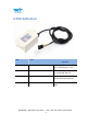
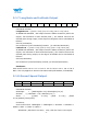
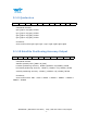
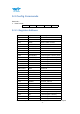
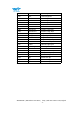
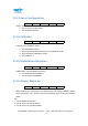
Table Of Contents
- Tutorial Link
- Contact
- Application
- Contents
- 1 Overview
- 2 Features
- 3 Specification
- 5 Communication Protocol
- 5.1 Output Data Format
- 5.2 Config Commands
- 5.2.1 Register Address
- 5.2.2 Save Configuration
- 5.2.3 Calibrate
- 5.2.4 Installation Direction
- 5.2.5 Sleep/ Wake up
- 5.2.6 Algorithm Transition
- 5.2.7 Gyroscope Automatic Calibration
- 5.2.8 Return Content
- 5.2.9 Return Rate
- 5.2.10 Baud Rate
- 5.2.11 Set X Axis Acceleration Bias
- 5.2.12 Set Y Axis Acceleration Bias
- 5.2.13 Set Z Axis Acceleration Bias
- 5.2.14 Set X Axis Angular Velocity Bias
- 5.2.15 Set Y Axis Angular Velocity Bias
- 5.2.16 Set Z Axis Angular Velocity Bias
- 5.2.17 Set X Axis Magnetic Bias
- 5.2.18 Set Y Axis Magnetic Bias
- 5.2.19 Set Z Axis Magnetic Bias
- 5.2.20 Set GPS baud

WTGAHRS2 | Datasheet v20-0523 | http://wiki.wit-motion.com/english
- 16 -
5.1.7 Longitude and Latitude Output
0x55
0x57
Lon0
Lon 1
Lon 2
Lon 3
Lat0
Lat 1
Lat 2
Lat 3
SUM
Calculated formular:
Longitude Lon = ((Lon 3<<24)| (Lon 2<<16)| (Lon 1<<8)| Lon 0
In NMEA0183 standard , GPS output format is ddmm.mmmmm (dd for the
degree, mm.mmmmm is after decimal point ), the module removes the
decimal point during output, so the degree of longitude can be calculated as
follows:
dd=Lon/100000000;
mm.mmmmm=(Lon%10000000)/100000;(% calculate Remainder)
Latitude Lat = ((Lat 3<<24)| (Lat 2<<16)| (Lat 1<<8)| Lat 0 (cm)
In NMEA0183 standard , GPS output format is ddmm.mmmmm (dd for the
degree, mm.mmmmm is after the decimal point ), the module removes the
decimal point during output, so the degree of latitude can be calculated as
follows::
dd=Lat/100000000;
mm.mmmmm=(Lat%10000000)/100000;(% calculate Remainder)
Checksum:
Sum=0x55+0x54+ Lon 0+ Lon 1+ Lon 2+ Lon 3+ Lat 0+ Lat 1+ Lat 2+ Lat 3
Note: This only applies to devices with GPS module(WTGAHRS1, WTGAHRS2)
5.1.8 Ground Speed Output
0x55
0x58
GPSHeightL
GPSHeightH
GPSYawL
GPSYawH
GPSV0
GPSV 1
GPSV 2
GPSV 3
SUM
Calculated formular:
GPSHeight = ((GPSHeightH<<8)| GPSHeightL)/10 (m)
GPSYaw =( (GPSYawH <<8)| GPSYawL)/10 (°)
GPSV = (((GPSV 3<<24)| (GPSV 2<<16)| (GPSV
2<<8)|GPSV0)/1000(km/h)
Checksum:
Sum=0x55+0x54+ GPSHeightL + GPSHeightH + GPSYawL + GPSYawH +
GPSV0+ GPSV 1+ GPSV 2+ GPSV 3