
User's Guide
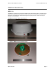
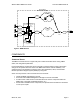
Table Of Contents

Wireless Matrix MBS2 User Guide Document MBUD-0086v1b
Satellite Modem
The L-band satellite modem is used to communicate at L-band via the ISPD network. The
modem is provided with an omni-directional cross-dipole antenna. The satellite modem is
designed and manufactured by Wireless Matrix.
GPRS Modem
A GPRS terrestrial wireless modem is used to communicate on the AT&T Wireless Services
(AWS) GPRS network. The GPRS modem is a Motorola model G20 OEM module.
A monopole antenna is used with this modem.
802.11b Modem
The MBS2 uses a 802.11b WLAN modem to connect to the CSC wirelessly. By doing so, it
extends the range of a CSC user to several hundred feet from the MBS2. This “Wireless Tether”
also provides good in-building penetration, up to 150 feet.
The Wireless Tether supports all of the same functionality that a standard serial port connection
supports. The MBS2 is capable of routing the communications of multiple CSCs via the WAW.
Also, a CSC using one MBS2 may “Roam” to another MBS2 and use the latter to communicate
with the WAW network. With this flexible scheme, the MBS2 is truly a Base Station that is
mobile.
The MBS2 uses the Cisco Aironet 350 PCMCIA card for 802.11b communications. An elevated
dipole antenna is provided. The customer is responsible for providing the CSC with a wireless
modem card capable of communicating with the Wireless Tether modem and approved by
Wireless Matrix.
MBS2 supports ad-hoc mode for communications with a CSC, or infrastructure mode for
communications with an Access Point in an In-Yard Communications situation.
The MBS2 also has the capability to use the Wireless Tether to communicate with CSCs that use
a sleep mode for power conservation. See the Magic Packet section for details.
GPS Receiver
The GPS receiver option includes a GPS receiver and a separate patch antenna.
The GPS receiver is a Lassen LP, manufactured by Trimble. It measures position with an
accuracy of 25 meters
1
, velocity accurate to 0.1 meters/sec, and time accurate to 95 nano-
seconds.
The GPS information can be used by the Wireless Matrix AVL application, the application running
on the CSC, or another User Application stored on the MBS2.
The CSC application can access GPS information through command server primitives (refer to
Fehler! Verweisquelle konnte nicht gefunden werden. for details).
1
Subject to Selective Availability (SA)
March 04, 2004 Page 9