
Specifications


42
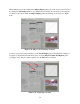
Global Positioning System (GPS) coordinates can be entered to automatically obtain aerial
images from TerraServer-USA or Google Maps. If the GPS coordinates and orientation of the
camera are known, the vehicle positions can be plotted on the aerial images as they pass through
the intersection (see Figure 6.52).
Figure 6.52. Combined camera and aerial view of a rural intersection
7. CONCLUSIONS AND RECOMMENDATIONS
Commercially available instruments for road-side data collection are significantly limited.
Recent advances in computer vision techniques for digital video analysis promise to overcome
many of these limitations. As demonstrated in this research, relatively inexpensive equipment
can be used to record and analyze digital video to measure safety-related variables that cannot be
easily measured using existing sensors.
This project implemented and tested a digital video analysis system for use at intersections based
on a single camera design. Video was recorded at both urban and rural non-signalized
intersections and was analyzed using the digital video analysis techniques developed in this
project. The results of the video analysis demonstrate the ability of the system to provide data
that can potentially be useful for the understanding of driver behavior. A significant advantage of
the system is that a large amount of data can be collected relative to the effort and expense
involved. Because this research is still in its early stages, there are a number of limitations to the
developed video analysis approach.
Given the significant promise of this research, it is recommended that the technology developed
in this project be deployed alongside an ongoing traffic safety study. With only minor increases
to the cost of an existing study, the benefits of these techniques could be fully demonstrated.