
User Manual

www . SkylarkFPV . com
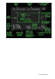
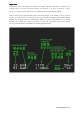
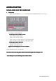
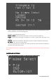
DISPLAYED
DISPLAYED
DISPLAYED
DISPLAYED INFORMATION
INFORMATION
INFORMATION
INFORMATION DESCRIPTION
DESCRIPTION
DESCRIPTION
DESCRIPTION
Description
Description
Description
Description Display
Display
Display
Display Range
Range
Range
Range
Latitude
Latitude
Latitude
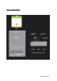
Latitude N is North Latitude, S is South Latitude, Unit is Degree 90.0N~0~90.0S
Longitude
Longitude
Longitude
Longitude E is East Longitude, W is West Longitude, Unit is Degree 180.0E~0~180.0W
Numbers
Numbers
Numbers
Numbers of
of
of
of GPS
GPS
GPS
GPS
satellites
satellites
satellites
satellites
Numbers of GPS satellite that can be received signal
currently.
0~9; 9 would be
displayed even more
than 9
Speed
Speed
Speed
Speed Total speed, unit is Km/ hour 0~999km/h
Current
Current
Current
Current Operation current, unit is A 0.0~99.9A
Voltage
Voltage
Voltage
Voltage System voltage, unit is
V.
it would flash when under voltage. 0.0~99.9V
Electricity
Electricity
Electricity
Electricity
consumption
consumption
consumption
consumption
The electricity consumed from system start-up till now, unit
is mAH
0.0~9999mAH
Remaining
Remaining
Remaining
Remaining electricity
electricity
electricity
electricity The battery symbol indicates the remaining electricity level,
when it is nearly used up, the symbol would flash.
It takes a 2200mAH
battery as indication
standard.
Point
Point
Point
Point of
of
of
of departure
departure
departure
departure Indicate the point of departure
Location
Location
Location
Location &
&
&
& direction
direction
direction
direction The plane icon indicates the existing location & direction
corresponding to the point of departure.
Up
: North,
Down
: South,
Left
: West,
Right
: East. The flying
direction is shown by the plane icon.
Altitude
Altitude
Altitude
Altitude
corresponding
corresponding
corresponding
corresponding to
to
to
to the
the
the
the
point
point
point
point of
of
of
of departure
departure
departure
departure
Altitude that corresponding to the point of departure. The
figure can be negative, unit is meter.
-9999~9999m
Returning
Returning
Returning
Returning angle
angle
angle
angle &
&
&
&
direction
direction
direction
direction
Indicate the required angle and direction for a returning
journey, the unit for angle is degree. When angle is less than
5 degree, it would consider as accurate, so direction would
not be displayed.
Horizontal
Horizontal
Horizontal
Horizontal distance
distance
distance
distance
corresponding
corresponding
corresponding
corresponding to
to
to
to the
the
the
the
point
point
point
point of
of
of
of departure
departure
departure
departure
The horizontal distance corresponding to the point of
departure, the unit would be adjusted automatically.
0~99.9km
SD
SD
SD
SD Card
Card
Card
Card indication
indication
indication
indication When there is a SD card, this information would be
displayed. If there is problem in data saving, it would flash.
Signal
Signal
Signal
Signal indication
indication
indication
indication of
of
of
of
remote
remote
remote
remote control
control
control
control
When the device is under interference and out of control
range, it would flash.
Flying
Flying
Flying
Flying time
time
time
time The flying time is accumulated from the first take-off. When
there are 4 or more GPS satellites and the speed exceeds 5m/s
the first time, it starts counting.