
User Manual

Guilin Feiyu Technology Incorporated Company.
http://www.feiyu-tech.com uavservice@feiyu-tech.com
Page 33
Appendix
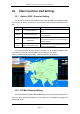
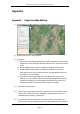
Appendix : Flight Area Map Making
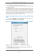
(1) Download the FY Offline Map from our official website and open it.
(2) Name the map on the “project names”.
(3) Map types:
A. For Chinese users, Baidu HD Satellite is suitable and better, it can offer high
quality Map in some areas. But the Map cant be found in some other remote
areas.
B. Google Satellite(China Server) is suitable and better for Chinese users.
C. Google Satellite(Global Server) is suitable for people from all over the
world expect China and a few other countries, the latter people cannot use
the global ser ver successfully.
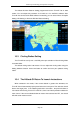
D. If you cannot load the appointed area on the Map for the reason of the
Explorer, you can use the function of “Enter Range”(Google Global Server),
and input the loading area on the software. But Chinese and a few users
from other countries may cannot use this function successfully.
(4) Choose the map resolution.
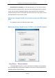
(5) Click the right mouse bottom both at the upper left corner and the bottom right
corner of the suitable area, then it will display a yellow selection area or six
coordinate points enclosing a rectangular.
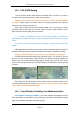
(6) The procedure begins to work when you click the function ”download”. The
green words in the log indicatting that you have loaded Map tiles successfully. If