
Data Sheet
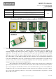

LOCOSYS Technology Inc.
20F.-13, No.79, Sec. 1, Xintai 5th Rd.,
Xizhi District, New Taipei City 221, Taiwan
℡ 886-2-8698-3698
886-2-8698-3699
www.locosystech.com
Page
7/20
© 2006 LOCOSYS Technology Inc.
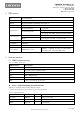
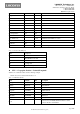
Message ID
$GPGSV
GSV protocol header
Total number of messages
1
3
Range 1 to 4
Message number
1
1
Range 1 to 4
Satellites in view 12
Satellite ID 28
Channel 1 (Range 01 to 196)
Elevation 81
degrees
Channel 1 (Range 00 to 90)
Azimuth 285
degrees
Channel 1 (Range 000 to 359)
SNR (C/No) 42
dB-Hz
Channel 1 (Range 00 to 99, null when not tracking)
Satellite ID 20
Channel 4 (Range 01 to 32)
Elevation 51
degrees
Channel 4 (Range 00 to 90)
Azimuth 077
degrees
Channel 4 (Range 000 to 359)
SNR (C/No) 46
dB-Hz
Channel 4 (Range 00 to 99, null when not tracking)
Checksum *73
<CR> <LF>
End of message termination
1. Depending on the number of satellites tracked multiple messages of GSV data may be required.
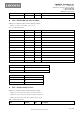
RMC---Recommended Minimum Specific GNSS Data
Table 5.1-9 contains the values for the following example:
$GPRMC,053740.000,A,2503.6319,N,12136.0099,E,2.69,79.65,100106,,,A*53
Table 5.1-9 RMC Data Format
Name
Example
Units
Description
Message ID
$GPRMC
RMC protocol header
UTC Time 053740.000
hhmmss.sss
Status A
A=data valid or V=data not valid
Latitude 2503.6319
ddmm.mmmm
N/S Indicator N
N=north or S=south
Longitude 12136.0099
dddmm.mmmm
E/W Indicator E
E=east or W=west
Speed over ground 2.69
knots
True
Course over ground 79.65
degrees
Date 100106
ddmmyy
Magnetic variation
degrees
Variation sense
E=east or W=west (Not shown)
Mode A
A=autonomous, D=DGPS, E=DR, N=Data not valid,
R=Coarse Position, S=Simulator
Checksum *53
<CR> <LF>
End of message termination