
User's Manual


© 2010 - 2015 Persistent Systems, LLC – All Rights Reserved 59
WEB MANAGEMENT INTERFACE REFERENCE
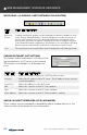
Latitude Allows the user to manually define the node’s latitude in decimal degrees
(only visible in “Manual Entry” mode)
Longitude Allows the user to manually define the node’s longitude in decimal de-
grees (only visible in “Manual Entry” mode)
Altitude Allows the user to manually define the node’s altitude in feet above GPS
ellipsoid - approximately equal to feet above mean sea level (MSL) (only
visible in “Manual Entry” mode)
External Update
UDP Port
Defines the port number to receive position updates via the external
Wave Relay
®
‘wr-update-gps’ command (only visible in “Use External
Feed” mode)
ESD UDP Port Defines the port number to receive position updates via an external ESD
feed (only visible in “Use ESD Feed” mode)
CoT UDP Port Defines the port number to receive position updates via external CoT
feed (only visible in “Use CoT Feed” mode)
CDF UDP Port Defines the port number to receive position updates via an external CDF
feed (only visible in “Use CDF Feed” mode)
Update Interval Controls how often nodes report information back to visualiziation
server with visualization enabled - Smaller values allow finer mobile node
movements in Google
™
Earth. Shorter update intervals require more
bandwidth.