
User's Manual


© 2010 - 2015 Persistent Systems, LLC – All Rights Reserved42
WEB MANAGEMENT INTERFACE REFERENCE
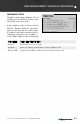
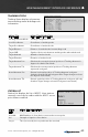
Internal GPS Status:
MENU ITEM MENU ITEM DESCRIPTION
Fix Type How node is connected (3D, 2D, or none)
Latitude Latitude of current node
Longitude Longitude of current node
Altitude Altitude above sea level of current node
Speed Speed of node (m/s) in the horizontal plane
Track Path of travel with respect to the Earth expressed in degrees - 000 degrees
is North (angle increases clockwise through 360 degrees)
Climb Speed of node (m/s) in the vertical plane
Fix Time When node obtained a satellite fix
Number of
satellites
Number of satellites node is connected to
ID/PRN ID/PRN of each satellite node is connected to
Signal Strength of the connection between node and each satellite
NTP Server Status of the NTP server (available or unavailable)
GPS STATUS
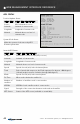
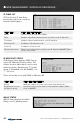
Position Update Status:
MENU ITEM MENU ITEM DESCRIPTION
Source GPS information source
Latitude Latitude of current node
Longitude Longitude of current node
Altitude Altitude above sea level of
current node
System Clock Status:
When the system clock was set by GPS
Current system time