
User's Manual

E. System requirement
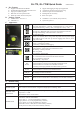
Minimum Configuration Recommended Configuration
- Windows XP
- Pentium 3, 500Mhz
- 256M RAM
- 400MB disk space
- Network speed: 128Kbits/sec
- 3D-capable video card with 16Mbytes of VRAM
- 1024x768, "16-bit High Color" screen
- Windows 7, 8, 10 PC version
- Pentium 4 2.4GHz+ or AMD 2400xp+
- 1G RAM
- 2 GB of free disk space
- Network speed: 768 Kbits/sec or better (DSL/Cable)
- 3D-capable video card with 32 MB of VRAM or greater
- 1280x1024, "32-bit True Color" screen
[Notes and Warning] If you have recorded more than 250,000 way points in your GL-770, it may take the entire resource of
your computer to show all the logged data in Google Earth. Therefore, with not enough RAM capacity the computer may
hang up (system frozen).
F. Getting Started
Step1. Fully charge the battery via USB port first before starting to use.
Step2. Press and hold Power bottom for 3 seconds to turn on / off the device.
Step3. Acquire GPS signal
Orange LED will start blinking when GPS signal is acquired and have a valid fix.
Step4. Push POI to mark a specific waypoint.
Vibrating/beeping feedback are provided when POI button is pressed
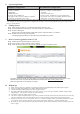
G. How to extract logged data from GL-770
Step1. Install LogView and USB driver (refer to CD)
Step2. Power on GL-770 and connect to PC or laptop.
Step3. Click “Read from device” button on the top left of LogView software panel
To display the track points on Google Earth, your PC must have installed Google Earth and have the
Internet connection. Google Earth installation (Download from http://earth .google.com/
)
[Note] Google Earth is a trademark of Google.
H. Helpful tips
Some vehicles using heavy metallic sun protecting coating on windshield may affect GPS signal reception.
Streets with high rising buildings may affect GPS signal reception.
Tunnel and indoor parking garage may affect signal reception.
In general, GPS signal reception best in open space where it can see clear sky. Weather condition will also affect
GPS reception – rain & snow contribute to worse sensitivity.
Low battery status may affect signal reception.
This device outputs coordinates data every second, therefore the actual position and the position shown on your map
may have slight time delay. This may happen when you drive at higher speed or make a turn around a corner.
For the device not in use over several days, allow it 1~3 minutes to obtain satellite constellation information and fix
your position, this is called “Cold Start”. Upon battery replacement, GPS device will do Cold Start again.
If your device can not fix position for more than 20 minutes, please change to another location with open space and
then try again.