TomTom Go Navigation User Manual
Contents Welcome to navigation with TomTom 5 Get going 6 Starting the app .................................................................................................................................................. 6 Subscriptions ...................................................................................................................................................... 6 Language .............................................................................................................
Starting a search ............................................................................................................................................... 27 Working with search results ............................................................................................................................. 29 About postcodes...............................................................................................................................................
Updating locations for cameras and hazards ................................................................................................... 62 Danger Zones 63 About danger zones and risk zones .................................................................................................................. 63 Danger zone and risk zone warnings ................................................................................................................ 63 Changing the way you are warned ............
Welcome to navigation with TomTom This User Manual explains all you need to know about your new TomTom Go Navigation app. The Get going chapter is a great place to start. You'll learn all about starting up and setting up your app, and you'll see a quick introduction to TomTom services. To help you avoid traffic delays and get to your destination quicker, you can use TomTom services even on the routes you drive every day. For information about what you see in the app, go to What's on the screen.
Get going Starting the app Tap this button on your device to start the TomTom Go Navigation app. TomTom Go Starting the app for the first time When you start the TomTom Go Navigation app for the first time, you see the following screens: Tour - These screens show you the main features of the app. Enable Location Services - You are asked if the app can use your current location. You must agree to this so that the app can find your location on the map.
If a free trial is offered with your subscription (offer limited to one free trial period per user), the subscription will only be charged at the advertised price at the end of the trial period. You can manage your subscriptions and turn off the auto-renewal at any time on the App Store account management page. If you cancel the subscription while still in the trial period, you will not get charged.
Online Search - Enhance your search results with online data. Note: Some TomTom services might not be available in your current location. Note: If you choose not to send location information to us, you will no longer receive our services. This is because services need to send the location of your device to TomTom in order to receive the traffic information related to where you are. Important: To use TomTom services you need a continuous data connection.
Some devices need a data connection to obtain a GPS location. If your device has no GPS reception, the navigation app uses positioning information from Wi-Fi networks or mobile phone towers. This information is used for route planning and to determine your approximate location, but is not accurate enough to use for route instructions. Installing in your car Only use a suitable mount to hold your device when you are using it in your car. Be careful where you install your device in your car.
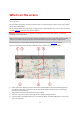
What's on the screen The map view The map view is shown when you have no planned route. Your actual location is shown as soon as your device has found your GPS location. You can use map view in the same way as you might look at a traditional paper map. You can move around the map using gestures, and zoom using the zoom buttons.
Note: If your TomTom Go Navigation app cannot find your location the symbol appears grey. Note: You cannot change the current location symbol. 5. Main Menu button. Select the button to open the Main Menu. 6. Traffic information. Select the traffic incident to display information about the traffic delay. 7. Map symbols. Symbols are used on the map to show your destination and your saved places: Your destination. Your home location. You can set your home location in My Places.
8. Back button. This button returns the map to an overview of your whole route or, if no route is planned, moves the map to put your current location at the centre. 9. Location details. Tap and hold anywhere on the map and you see the details of that location. 10. Pop-up menu. Tap on this symbol to open the pop-up menu, which gives you a list of actions you can take. 11. Drive button. This button prepares a route to the selected location.
You can move two fingers up and down the screen to adjust the 3D viewing angle. Tip: When you have planned a route and the 3D guidance view is shown, select the switch view button to change to the map view and use the interactive features. 1. Switch view button. Select the switch view button to change between the map view and the guidance view. 2. Zoom buttons. Select the zoom buttons to zoom in and out. Tip: You can also pinch to zoom in and out. 3. Instruction panel.
8. Clear route button. Select this button to clear your current route. The route bar The route bar is shown when you have planned a route. It has an arrival information panel at the top, and a bar with symbols underneath. Note: The distance ahead shown by the route bar depends on the overall length of your route. The arrival information panel shows the following information: The estimated time that you will arrive at your destination.
The route bar also shows status messages, for example Finding fastest route or Playing route preview. Below the route bar is a button that immediately clears your current route. Distances and the route bar The distance ahead shown on the route bar depends on the length of your route, or the distance remaining on your route. For remaining distances longer than 50 km (31 miles), only the next 50 km (31 miles) is shown. The destination icon is not shown.
Drive to Work Recent Destinations Current Route My Places Parking Petrol Station Report Speed Camera Select this button to drive to your work location. If this button is not included in your Main Menu, go to My Places to set up your work location. Select this button to open the list of your recent destinations. Select a recent destination to plan a route to that destination. Select this button to clear or change your planned route. Select this button to show your saved places.
Report Risk Zone Select this button to report a risk zone. Note: This feature is only available when you are in France. TomTom Services TomTom Labs Maps Select this button to see the status of each TomTom Service that your app uses. Select this button to find details of new features fresh from TomTom. Select this button to open the Maps Menu. Support Select this button to open the Support screen. Settings Select this button to open the Settings Menu.
Guidance and Alerts Use this button choose if you want to hear: Alerts only Guidance only Alert and Guidance No sound. Note: The options available for the guidance voice can be set in the Voices page in Settings. Other buttons On the map or guidance view, select the Main Menu button to open the Main Menu. The following buttons are available in the Main Menu screen, in addition to the Main Menu buttons: Select this button to return to the previous screen.
Double tap Touch one finger on the screen twice in rapid succession. Example of when to use this: Zooming in. Drag Put one finger on the screen and move it across the screen. Example of when to use this: Scrolling a screen. Flick Flick the tip of a single finger across the screen. Example of when to use this: Scrolling a big distance on the screen. Press and hold Put one finger on the screen for more than 0.5 second. Example of when to use this: Selecting a location on the map.
Traffic About TomTom Traffic TomTom Traffic is a TomTom service providing real-time traffic information. In combination with historical road usage data, TomTom Traffic helps you plan the optimum route to your destination taking into account the current local traffic conditions and the weather. Your TomTom Go Navigation app regularly receives information about the changing traffic conditions.
For a complete list of incident types, see Traffic incidents. Looking at traffic on your route Information about traffic incidents on your route is shown in the route bar on the right-hand side of the map and guidance views. The route bar tells you about traffic delays while you are driving, using symbols to show you where each traffic incident is located on your route. When using the map view, you can also select symbols on the map itself.
Lane closure Road closure Rain Fog Ice or snow Wind The symbol or number at the start of the incident shows the type of incident or the delay in minutes, for example 4 minutes. The colour of the incident indicates the speed of traffic relative to the maximum allowed speed at that location, with red being the slowest. The stripes on the traffic jam are also animated to show the speed of the traffic, where appropriate. Traffic speed is 0% to 20% of the allowed speed.
A warning symbol is shown in the route bar (page 14). The route bar zooms in to the start of the traffic jam. Your distance to the start of the traffic jam is shown in the route bar. The colour of the road on the route bar changes to orange or red, depending on the severity of the traffic jam. The background colour of the route bar background changes to red if you are driving too fast towards the traffic jam. You hear a warning sound.
Moving Lane Guidance Note: Lane guidance is not available for all junctions or in all countries. Moving Lane Guidance helps you prepare for motorway exits and junctions by showing the correct driving lane for your planned route. As you approach an exit or junction, the lane you need is shown on the screen. Tip: To close the lane image, select anywhere on the screen. You can also switch off lane guidance. Go to Appearance in Settings to change the Motorway exit previews setting.
TomTom MyDrive About TomTom MyDrive TomTom MyDrive is the easy way to save your personal navigation information. MyDrive synchronises your TomTom Go Navigation using your TomTom account. You can use MyDrive on a computer by visiting mydrive.tomtom.com (http://mydrive.tomtom.com - http://mydrive.tomtom.com). Use TomTom MyDrive in a web browser to find locations on your computer, then add them to your My Places list.
Your TomTom Go Navigation app syncs with your TomTom account and receives the new Favourites location. The location is stored in My Places (page 57). Syncing My Places locations with MyDrive When you are logged in to MyDrive in your TomTom Go Navigation app, the locations you have added to My Places (page 57) are automatically synced with your TomTom account. You can see your My Places locations when you are logged in to MyDrive in a web browser.
Using search About search You use search to find a wide range of places and then navigate to them. These places are found either from the information currently stored in your app, or if your device is connected to the internet, from the online data available. You can search for the following: A specific address, for example, 123 Oxford Street, London. A partial address, for example, Oxford st Lon. A type of place, for example, petrol station or restaurant.
The search screen opens with the keyboard showing. 2. Use the keyboard to enter the name of the place you want to plan a route to, enter the type of Point Of Interest (POI), or select one of the popular POI categories to immediately see a list of these locations in your area. Tip: If you press and hold (page 18) a letter key on the keyboard, you get access to extra characters if they are available. For example, press and hold the letter "e" to access characters 3 e è é ê ë and more.
Tip: You can switch between seeing the results on the map or in a list by selecting the list/map button: 4. Select a POI type or an individual POI. If you selected a POI type, select a POI. The location is shown on the map. Working with search results Your search results are shown in the columns Addresses, Points of Interest and Contacts. Select a column or swipe left or right to show the column.
When you select an address from the list of search results, you can choose to show it on the map, add a crossroad or plan a route to that chosen location. To get an exact address you can add the house number. If you show the result on the map, you can use the pop-up menu to add the location to My Places. Note: The best search results are shown on the map. When you zoom in, the lower ranked search results are gradually shown.
This type of postcode is still very useful in reducing the number of search results. For example, a search for Neustadt in Germany returns a long list of possible results. Adding a space followed by the postcode for an area narrows the results down to the Neustadt that you are looking for. As another example, if you want to search in a city, enter a postcode for an area and select the city centre you are searching for from the results.
Planning a route using search Planning a route to an address using search Important: In the interest of safety and to avoid distractions while you are driving, you should always plan a route before you start driving. To plan a route to an address using search, do the following: 1. Tap on the search bar at the top of the map, or select Search from the main menu. 2. Use the keyboard to enter the address that you want to plan a route to.
5. Enter the house number if you have one and haven't entered it already. Tip: If you enter a house number that is not found, then the number appears red. The nearest house number that is found is shown in the Drive button. You can enter a new house number, or you can select Drive to drive to the nearest house number. 6. To plan a route to this destination, select Drive. A route is planned and then guidance to your destination begins.
The city name is shown in the right side of the search input box. 5. Select the city centre. The city centre location is shown on the map. 6. To plan a route to this destination, select Drive. A route is planned and then guidance to your destination begins. As soon as you start driving, the guidance view is shown automatically. Tip: If your destination is in a different time zone, you see a plus (+) or a minus (-) sign and the time difference in hours and half hours in the arrival information panel.
2. Use the keyboard to enter the name of the place you want to plan a route to, enter the POI category or select one of the popular POI categories to immediately see a list of these locations in your area. 3. If you want to see more POI categories, select the More button. This shows you the main popular POI categories. 1. To choose from all the available POI categories, select All Categories.
2. As you type, suggestions based on what you have entered are shown. You can continue typing or select a suggestion. Tip: To see more results, hide the keyboard or scroll down the results list. Tip: You can switch between seeing the results on the map or in a list by selecting the list/map button: 3. Select a POI category or an individual POI. If you selected a POI category, select a POI. The location is shown on the map. 4. To plan a route to this destination, select Drive.
Legal - Solicitors Financial institution Legal - other services Food services Convenience store Fast food restaurant Restaurant Chinese restaurant Accommodation Hotel or motel Luxury hotel Camping ground Economy chain hotel Emergency services Hospital or polyclinic Dentist Police station Veterinarian Doctor Fire station Car-related services Outside parking Petrol station Parking garage Car wash Car dealer Vehicle inspection centre Rental car facility Electrical car charging point(s)
Rental car parking Car repair facility Embassy Pet services Government office Telecommunication Company Community service Post office Pharmacy Shopping centre Beauty services Tourist information office Shop College or university School Library Convention centre Casino Winery Theatre Tourist attraction Cinema Zoo Concert hall Amusement park Other services Education Leisure 38
Museum Exhibition centre Opera Cultural centre Nightlife Leisure centre Children's Farm Sport Playing field Swimming pool Mountain peak Water sports Beach Tennis court Park or recreation area Ice skating rink Yacht basin or marina Sports centre Stadium Golf course Church Place of worship Railway station Mountain pass Airport Scenic or panoramic view Religion Travel 39
Ferry terminal Postcode Note: Not used in all countries. Border crossing Residential area Bus station City centre Toll gate Electrical car charging stations Rest area Truck stop Planning a route to a contact using search Important: In the interest of safety and to avoid distractions while you are driving, you should always plan a route before you start driving.
Tip: To see more results, hide the keyboard or scroll down the results list. Tip: You can switch between seeing the results on the map or in a list by selecting the list/map button: 3. Select the contact you want. Your contact is shown on the map. Note: If your contact has multiple addresses, all the locations are shown on the map. Select a location to show the address 4. To plan a route to this destination, select Drive. A route is planned and then guidance to your destination begins.
2. When you have found your destination on the map, select it by pressing and holding the screen for about one second. A pop-up menu shows the nearest address. 3. To plan a route to this destination, select Drive. A route is planned and then guidance to your destination begins. As soon as you start driving, the guidance view is shown automatically. Tip: You can use the location you selected in other ways, such as adding it to My Places (page 57), by selecting the pop-up menu button.
Your chosen Place is shown on the map with a pop-up menu. 3. To plan a route to this destination, select Drive. A route is planned and then guidance to your destination begins. As soon as you start driving, the guidance view is shown automatically. Tip: If your destination is in a different time zone, you see a plus (+) or a minus (-) sign and the time difference in hours and half hours in the arrival information panel. The estimated time of arrival is the local time at your destination.
Tip: If your destination is in a different time zone, you see a plus (+) or a minus (-) sign and the time difference in hours and half hours in the arrival information panel. The estimated time of arrival is the local time at your destination. Tip: You can add a stop to a route that you have already planned. Planning a route to a geotagged photo Important: In the interest of safety and to avoid distractions while you are driving, you should always plan a route before you start driving.
A pop-up menu shows a list of options. 4. Select Use as Starting Point. 5. Repeat the steps above to select a destination for your route. Your route is planned using your chosen starting point and destination. The estimated journey time is shown at the top of the route bar. Tip: Stops, POIs and Places can all be selected as starting points using their pop-up menus. 6. To drive to the starting point, select Drive at the top of the screen.
1. Select the Main Menu button to open the Main Menu. 2. Select Parking. The map opens showing the locations of car parks. If a route is planned, the map shows car parks near your destination. If a route isn't planned, the map shows car parks near your current location. You can change the screen to show a list of car parks by pressing this button: You can select a car park from the list to locate it on the map.
If you want to change how the search is done, select the button to the right of the search box. You can then change where the search is carried out, for example, to search near you or the whole map. 3. Select a car park from the map or list, and then open the pop-up menu. The pop-up menu opens on the map showing the name of the car park. 4. Select Drive. The parking replaces your final destination. If you want to keep your existing destination, select the option Add to Current Route.
2. Select Petrol Station. The map opens showing the locations of petrol stations. If a route is planned, the map shows petrol stations along your route. If a route isn't planned, the map shows petrol stations near your current location. You can change the screen to show a list of petrol stations by pressing this button: You can select a petrol station from the list to locate it on the map. If you want to change how the search is done, select the button to the right of the search box.
A pop-up menu opens on the map showing the name of the petrol station. 4. Select Drive. The petrol station replaces your final destination. If you want to keep your existing destination, select the option Add to Current Route. The petrol station is then added as a stop immediately before the final destination and your existing destination is not changed. A route is planned and then guidance to your destination begins. As soon as you start driving, the guidance view is shown automatically.
Changing your route The Current Route menu When you have planned a route, select the Current Route button in the Main Menu to open the Current Route Menu. The following buttons are available in the menu: Clear Route Select this button to clear the currently planned route. The Current Route Menu closes and you return to the map view (page 10). Skip Next Stop Select this button to skip the next stop (page 56) on your route.
An instruction arrow. An instruction description. The distance between two consecutive instructions. Exit number. The full addresses of stops on your route. Tip: Select an instruction to see a preview of that section of the route in the map view. You can also select the instruction panel in the guidance view to see turn-by-turn text instructions. Share Arrival Time Select this button to share your arrival time with friends using other apps on your device.
Avoiding a blocked road If there is a blocked road on your route you can change your route to avoid it. 1. In the guidance view, select the current location symbol or the speed panel. Tip: The speed panel is only shown when you have started driving on your route. 2. Select Avoid Blocked Road. A new route is found that avoids the blocked road. You may get shown up to two alternatives depending on the road network between you and your destination.
5. Select Avoid. A new route is found that avoids your chosen route section. The new route is shown on the map view. Note: It may not be possible to find an alternative route around the route section if none exists. Guidance to your destination resumes avoiding your chosen route section. As soon as you start driving, the guidance view is shown automatically.
Fastest route - the fastest route to your destination. Your route is constantly checked taking into account the traffic conditions. Shortest route - the shortest route to your destination. This may not be the fastest route, especially if the route is through a town or city. Most eco-friendly route - the most fuel-efficient route. Winding route - the route with the most turns. Avoid motorways - this type of route avoids all motorways. Walking route - this type of route is optimised for walking.
A new route is found that avoids the feature. The new route is shown on the map view. Note: It may not be possible to find an alternative route around the route feature if none exists. Guidance to your destination resumes. As soon as you start driving, the guidance view is shown automatically. Avoiding an incident or route feature using the route bar You can avoid an incident or route feature that is on your route.
Skipping the next stop on your route 1. In the Main Menu, select Current Route. 2. Select Skip Next Stop. The map view is shown. The next stop on your route is deleted and your route is recalculated. Reordering stops on a route Note: It is also possible to reorder the stops using the route bar. 1. In the Main Menu, select Current Route. 2. Select Reorder Stops. The map view is shown with the route cleared. The starting point, destination and all the stops are shown. 3.
My Places About My Places My Places provides an easy way to select a location without the need to search for the location each time. You can use My Places to create a collection of useful addresses. The following items are always in My Places: Home and Work - These locations can be your home and work addresses, or places you often visit. Choosing locations lets you use the Drive Home and Drive to Work buttons in the main menu.
Zoom in on the map at the location you want to select. Press and hold to select the location, then select Set. Select the Search button and search for a location. Select a location to set as home or work, then select Set. Changing your home or work location You can change your home or work location in the following ways. Changing your home or work location using My Places 1. In the Main Menu, select My Places. 2. Select Home or Work. The location is shown on the map, with a pop-up menu. 3.
3. Select the pop-up menu button. 4. Select Add to My Places. The name of the location is shown in the edit screen. 5. Edit the name of the location so you can easily recognise it. 6. Select Done to save your location in the My Places list. The location you added is shown with a marker on the map. Adding a location to My Places using search 1. Search for a location and select it. 2. When the map view shows the location, select the pop-up menu button. 3. Select Add to My Places.
Speed Cameras About speed cameras The Speed Cameras service warns you about the following camera locations: Fixed speed camera locations. Mobile speed camera locations. Mobile speed camera hotspots. Average speed camera locations. Speed enforcement zones. Red light camera locations. Traffic restriction cameras. The Speed Cameras service also warns you about accident blackspot locations. To get TomTom services in your TomTom Go Navigation app, your device must have a mobile data connection.
Symbol shown on map Symbol shown in route Description bar Mobile speed camera - this type of camera checks the speed of passing vehicles and can be moved to different locations. Mobile speed camera hotspots - this type of warning shows places where mobile cameras are often used. Average speed cameras - these types of cameras measure your average speed between two points. You are warned at the start and end of the average speed check area.
You can then set how you want to be warned for the different types of cameras and hazards. You can choose to be warned, warned only if you are speeding, or never warned. Reporting a new speed camera If you pass a new speed camera that you were not warned about, you can report it instantly. Note: To report a speed camera, your device must have a mobile data connection. You can report a speed camera in the following ways: Using the speed panel to report a speed camera 1.
Danger Zones About danger zones and risk zones The Danger Zones service warns you about danger zones and risk zones on your route when you are in France. Since 3rd January 2012, it has been illegal to receive warnings about the position of fixed or mobile speed cameras when you are driving in France. To be compliant with this change in French law, speed camera locations are no longer reported but instead areas of danger are indicated as danger zones and risk zones.
Symbol shown on map Symbol shown in route Description bar Danger zone - this type of warning is only given in France. You are warned at the start and end of the danger zone. Risk zone - this type of warning is only given in France. You are warned at the start and end of the risk zone. You can change the way you are warned about danger and risk zones. Changing the way you are warned To change the way you are warned about danger zones, select Sounds & Warnings in the Settings menu.
Updating locations for danger zones and risk zones The locations of danger zones and risk zones can change frequently. New zones can also appear without warning. When connected to TomTom services, all zone updates are received in real time. You do not need to do anything to receive updates – they are sent to your navigation app automatically.
Maps Select Maps in the Main Menu. You see list of Map Areas (continents). The maps available are complete countries, or if the country is large, parts of countries. Note: To plan a route between points on different maps, you must have all the maps that the route passes through, downloaded onto your device. From this screen, you can either: Add maps to your device. Delete the maps on your device. Select a map from the list of maps that you have downloaded to your device.
Apple CarPlay About CarPlay You can use the TomTom Go Navigation app on head units that are compatible with Apple CarPlay. Once you have connected your iPhone, the TomTom Go Navigation app will be available on the head unit. Note: Refer to your iPhone documentation if you have problems connecting your device to the head unit. Launching the app Once you have connected your iPhone to the CarPlay stereo, the TomTom Go Navigation app icon appears in the list of available CarPlay apps.
What’s on the screen When you launch the TomTom Go Navigation app on your CarPlay screen, the map will be displayed. 1. Next instruction panel 2. Moving map 3. Current location icon 4. Route information (ETA, remaining time, remaining distance) 5. Current speed limit Tap anywhere on the map and buttons will be displayed on the right side of the screen, allowing you to interact with the map: 1. End Route. If you have a planned route, you can see End Route in the top right corner of the screen.
5. Pan map. Tap this button to display direction buttons that allow you to pan the map on the CarPlay screen. CarPlay Menu When connected to CarPlay you can access the menu as follows: 1. Tap anywhere on the map 2. Tap on “Menu” in the top left of the screen From the this menu, these options are available: Search. Select this option to find a destination. Start typing a POI category, a city, or an address. Matching results are shown. Volume.
Settings Appearance Select Settings in the Main Menu, then select Appearance. On this screen, you can change these settings: Day & Night Colours Select this option to choose between: Switch automatically between day colours and night colours, depending on the time of day. Always show day colours. Always chow night colours. Route bar Select Route bar to change the information you see in the route bar.
Show arrival information for Select this setting to show the arrival time for your final destination or your next stop. Select Route information to choose the POIs and route information you want to see in the route bar. Select Show cancel route to show the cancel route button at the bottom of the route bar. The default setting is ON. . Guidance view In Guidance view you can change these settings: Guidance view style Select this setting to choose from 3D or 2D versions of the guidance view.
Route Planning Select Settings in the Main Menu, then select Siri Shortcuts. Always plan this type of route The types of route you can choose from are as follows: Fastest route - the route which takes the least time. Shortest route - the shortest distance between the locations you set. This may not be the quickest route, especially if the shortest route is through a town or city. Most eco-friendly route - the most fuel-efficient route for your journey.
Safety warnings You can set how you want to be warned for different types of danger zones and safety hazards. You can choose to be always warned, warned only if you are speeding, or never warned. Traffic jam ahead Traffic jam warnings in the route bar are part of TomTom Traffic. You can choose never to be warned, or to be warned sooner when approaching a traffic jam. When speeding You can choose to be warned if you exceed the speed limit by more than 5 km/h or 3 mph.
Select Tell me when a faster route is available to receive a notification your device when a faster route is found. Tapping on the notification will return the TomTom Go Navigation app to the foreground and select the faster route. Select Return to app during a call to receive a notification after you answer a call. Tapping the notification will return the TomTom Go Navigation app to the foreground but the call will remain active.
Getting Help Support Select Support in the Main Menu. On this screen, you can see the following information to get help for your TomTom Go Navigation app: Replay tour Select this option to watch the guided tour again. The tour is short and includes basic information to help you get going with your new app. User manual This option opens an Internet link to a webpage where you can find the User Manual for your app.
Addendum Important Safety Notices and Warnings Global Positioning System (GPS) and Global Navigation Satellite System (GLONASS) The Global Positioning System (GPS) and Global Navigation Satellite System (GLONASS) systems are satellite-based systems that provide location and timing information around the globe. GPS is operated and controlled under the sole responsibility of the Government of the United States of America, who are responsible for its availability and accuracy.
Minnesota State Legislature Statutes Section 169.71, subdivision 1, section 2 restricts any person driving within the State of Minnesota from driving with a device suspended between the driver and the windshield. Many other states have enacted laws which restrict the placement of any object or material on the windshield, side or rear window that obstructs a driver's clear view of the road.
Copyright notices © 1992 - 2021 TomTom. All rights reserved. TomTom and the "two hands" logo are registered trademarks of TomTom N.V. or one of its subsidiaries. The software included in this product contains copyrighted software that is licensed under the GPL. A copy of that licence can be viewed in the Licence section. You can obtain the complete corresponding source code from us for a period of three years after our last shipment of this product. For more information, visit tomtom.com/gpl (tomtom.