
User guide

8.16.5 Map Summary
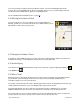
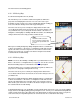
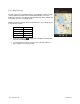
The entire route from your starting location to your destination is drawn on a map,
complete with the latest traffic alerts and traffic flow information. The route is
displayed as a blue line connecting the Start and Finish flags. When available, tap
on the traffic alert icons to read traffic details.
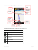
Highways and major roads with traffic flow information are color-coded by speed
in each direction of travel:
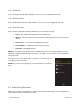
Speed Road Color
> 50 mph Green
30 – 50 mph Yellow
< 30 mph Red
Unknown Grey
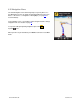
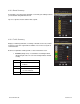
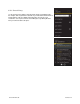
1. Choose the Traffic icon to toggle between hiding and showing traffic
(depends on availability).
2. Use the finger-pinch action to zoom in and out of the map. Slide your
finger along the screen to pan the map.
© 2012 TELENAV, INC. PAGE 29 OF 74