
Operation Manual


Training GPS Rides
- 6 - October 16, 2013
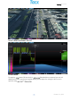
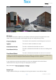
Screen 3: StreetView
GPS display
The course is outlined in a white line; the distance travelled is yellow. The opponents are also
shown. There are five possible camera angles that you can change during cycling:
Panoramic View 360 The camera circles around the rider 360 degrees from the air.
Top View The route is shown from above as a map.
Chase Camera Maximal The rider is followed from behind from the air.
Chase Camera Medium The rider is followed from behind from the air at ‘building-block
level’.
Chase Camera Minimal The rider is followed from behind from the air at ‘street level’.
In the settings you can determine whether the riders are displayed in 3D or dot. Various
modifications of the way the 3D maps are displayed are possible.
More information: The function buttons > Settings
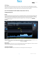
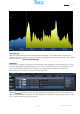
Bottom Panel
Using the Bottom Panel you can display the training information in three different ways:
If there is no internet connection you can still use Real Life Training. Instead of the Google Earth
3D maps the route is displayed in two dimensions. A Google license is required.