
Instruction Manual

Sygic GPS navigation
http://www.sygic.com/manuals/manual_en.html#useful[4/05/2009 10:36:45 AM]
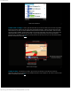
Show route instructions
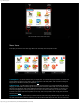
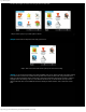
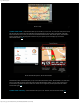
2) Show route as images - another great tool that allows you to show the whole route in several image slides.
Each turning point is viewed on its own image slide with detailed information - distance from the last turning point,
street name. You can also use several different tools that makes this function even more useful. There is a zoom
out/zoom in option available - tap the minus or plus icon on the top of the screen. The more you zoom in the more
detailed information you are able to see on the map. To get to next image slide or previous simply follow the
right/left arrow on the bottom of the screen. If you tap anywhere on the map screen you can easily switch between
the 3D or normal view of the map.
(up)
Show route as images
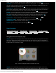
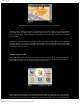
3) Show on map - use this when you want to get an idea of how would your route look like from the fly
perspective. Use zoom in/out tool to see more detailed information or tap anywhere on the screen to see the street
name or information about POIs.
(up)