
Wristop Computer User's Manual


Table Of Contents
- 1. General Information
- 2. How to Use your Suunto X10
- 3. Modes
- 3.1. General Information
- 3.2. Time Mode
- 3.2.1. Main display
- 3.2.2. Stopwatch
- 3.2.3. Alarm
- 3.2.4. Time/Date
- 3.2.5. Units
- 3.2.6. Setting the position format
- 3.2.7. General
- 3.3. Alti/Baro mode
- 3.3.1. Use
- 3.3.2. Alti use
- 3.3.3. Baro use
- 3.3.4. Alti/Baro data display
- 3.3.5. Reference altitude
- 3.3.6. Barometric Memory
- 3.3.7. Alarm
- 3.4. compass mode
- 3.4.1. Main display
- 3.4.2. Calibrating the compass
- 3.4.3. Declination
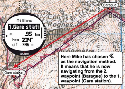
- 3.5. NAVIGATION MODE
- 3.5.1. Using the Navigation mode
- 3.5.2. Main display
- 3.5.3. Creating a route
- 3.5.4. Using a route
- 3.5.5. Editing routes and waypoints
- 3.5.6. Navigation data displays
- 3.5.7. Navidata
- 3.5.8. Track Back (Active track)
- 3.6. ACTIVITY MODE
- 3.6.1. Main Display
- 3.6.2. Activity
- 3.6.3. GPS fix
- 3.6.4. Memory
- 3.6.5. Track back (track log)
- 3.6.6. Activity data display
- 3.7. Function menu
- 3.7.1. GPS
- 3.7.2. Mark Memp
- 3.7.3. Mark Home
- 3.7.4. Find Home
- 3.7.5. Position
- 4. suunto X10 in action
- 5. Global positioning system (GPS)
- 6. suunto trek manager
- 7. SUUNTO TRACK EXPORTER
- 8. THIRD PARTY MAPPING SOFTWARE
- 9. SUUNTOSPORTS.COM
- 10. Technical Specifications
- 11. GPS DATUM LIST
- 12. local Grid LIST
- 13. GLOSSARY
- 14. Disclaimers
- 15. Disposal of the Device
62
As he enjoys the beautiful scenery on his hike towards Glacier de Tete Rousse, he
also notices that clouds are dispersing from the sky, which gives him a reason to
suspect that the barometric pressure has changed.
After arriving at Refuge l'Aig du Gouter, Mike sets the Baro mode on so that the
barometric pressure changes do not affect the altitude readings anymore.
Before hitting the sack, Mike plans out the next day's activities. He needs to get up
early because he has a long way to travel. So, first he checks the time of sunrise with
Start/Data in the Alarm menu and then sets an alarm to wake him up just before dawn.
He also compares the altitude reading to the one on the map to see that they match.
Then he leaves Suunto X10 to charge its battery.