
Wristop Computer User's Manual


Table Of Contents
- 1. General Information
- 2. How to Use your Suunto X10
- 3. Modes
- 3.1. General Information
- 3.2. Time Mode
- 3.2.1. Main display
- 3.2.2. Stopwatch
- 3.2.3. Alarm
- 3.2.4. Time/Date
- 3.2.5. Units
- 3.2.6. Setting the position format
- 3.2.7. General
- 3.3. Alti/Baro mode
- 3.3.1. Use
- 3.3.2. Alti use
- 3.3.3. Baro use
- 3.3.4. Alti/Baro data display
- 3.3.5. Reference altitude
- 3.3.6. Barometric Memory
- 3.3.7. Alarm
- 3.4. compass mode
- 3.4.1. Main display
- 3.4.2. Calibrating the compass
- 3.4.3. Declination
- 3.5. NAVIGATION MODE
- 3.5.1. Using the Navigation mode
- 3.5.2. Main display
- 3.5.3. Creating a route
- 3.5.4. Using a route
- 3.5.5. Editing routes and waypoints
- 3.5.6. Navigation data displays
- 3.5.7. Navidata
- 3.5.8. Track Back (Active track)
- 3.6. ACTIVITY MODE
- 3.6.1. Main Display
- 3.6.2. Activity
- 3.6.3. GPS fix
- 3.6.4. Memory
- 3.6.5. Track back (track log)
- 3.6.6. Activity data display
- 3.7. Function menu
- 3.7.1. GPS
- 3.7.2. Mark Memp
- 3.7.3. Mark Home
- 3.7.4. Find Home
- 3.7.5. Position
- 4. suunto X10 in action
- 5. Global positioning system (GPS)
- 6. suunto trek manager
- 7. SUUNTO TRACK EXPORTER
- 8. THIRD PARTY MAPPING SOFTWARE
- 9. SUUNTOSPORTS.COM
- 10. Technical Specifications
- 11. GPS DATUM LIST
- 12. local Grid LIST
- 13. GLOSSARY
- 14. Disclaimers
- 15. Disposal of the Device
61
4.1.2. First hiking day
While starting to hike, he sets the GPS fix to 1 sec in the Activity mode and selects
as the Activity option. He chooses the 1 sec option because he wants the GPS to
update the information as often as possible. Although this option also consumes a lot
of battery power, he knows that the battery will still last throughout his 4-hour hike. He
lets the GPS gather data from the satellites for 10 minutes while he tightens his
shoelaces, checks his backpack and puts on his harness.
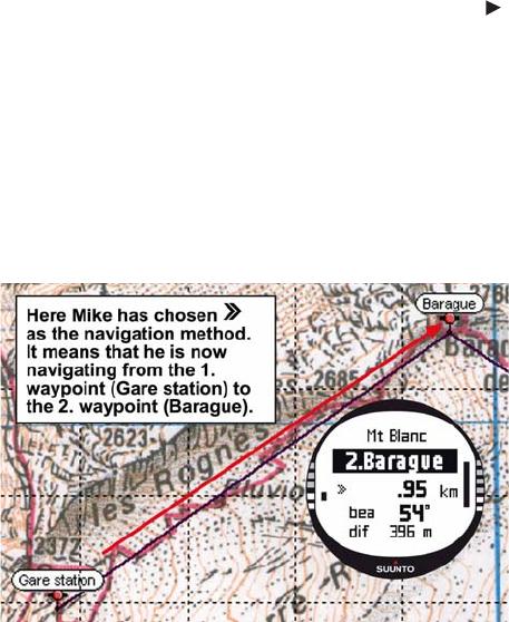
Mike has created the routes for both hiking days with Suunto Trek Manager and
uploaded them on his Suunto X10 in advance. Even though he does not really need a
navigational aid since the weather is fairly clear and paths are clearly marked, he
nevertheless activates a route in the Navigation mode since it does not consume that
much battery power even when the Activity is on. This allows him to practice using the
Navigation mode in safe conditions, and gather valuable route-specific information
such as distances, altitude differences and travel times.