
Wristop Computer User's Manual


Table Of Contents
- 1. General Information
- 2. How to Use your Suunto X10
- 3. Modes
- 3.1. General Information
- 3.2. Time Mode
- 3.2.1. Main display
- 3.2.2. Stopwatch
- 3.2.3. Alarm
- 3.2.4. Time/Date
- 3.2.5. Units
- 3.2.6. Setting the position format
- 3.2.7. General
- 3.3. Alti/Baro mode
- 3.3.1. Use
- 3.3.2. Alti use
- 3.3.3. Baro use
- 3.3.4. Alti/Baro data display
- 3.3.5. Reference altitude
- 3.3.6. Barometric Memory
- 3.3.7. Alarm
- 3.4. compass mode
- 3.4.1. Main display
- 3.4.2. Calibrating the compass
- 3.4.3. Declination
- 3.5. NAVIGATION MODE
- 3.5.1. Using the Navigation mode
- 3.5.2. Main display
- 3.5.3. Creating a route
- 3.5.4. Using a route
- 3.5.5. Editing routes and waypoints
- 3.5.6. Navigation data displays
- 3.5.7. Navidata
- 3.5.8. Track Back (Active track)
- 3.6. ACTIVITY MODE
- 3.6.1. Main Display
- 3.6.2. Activity
- 3.6.3. GPS fix
- 3.6.4. Memory
- 3.6.5. Track back (track log)
- 3.6.6. Activity data display
- 3.7. Function menu
- 3.7.1. GPS
- 3.7.2. Mark Memp
- 3.7.3. Mark Home
- 3.7.4. Find Home
- 3.7.5. Position
- 4. suunto X10 in action
- 5. Global positioning system (GPS)
- 6. suunto trek manager
- 7. SUUNTO TRACK EXPORTER
- 8. THIRD PARTY MAPPING SOFTWARE
- 9. SUUNTOSPORTS.COM
- 10. Technical Specifications
- 11. GPS DATUM LIST
- 12. local Grid LIST
- 13. GLOSSARY
- 14. Disclaimers
- 15. Disposal of the Device
33
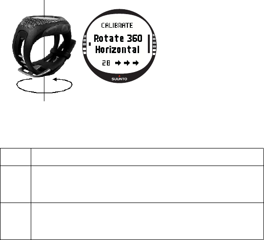
2. Hold your Suunto X10 horizontally level and rotate it 360 degrees in the direction of
the arrows for 30 seconds. If the calibration succeeds, the message ‘COMPLETE’ is
displayed. If it does not succeed, the message ‘FAILED’ is displayed. If this
happens, you have to calibrate it again.
3. When the calibration is finished, press ENTER to return to the main display.
3.4.3. Declination
You can set the compass declination manually or let the GPS do it. The compass
declination options are introduced in the table below:
Off Compass points to the magnetic north.
On Compass points to the geographic north based on the manually
set declination. Use this when you know the exact declination of
the location. Normally, you can find this on a topographic map.
Auto Compass points to the geographic north based on the declina-
tion from the GPS database value for the current location. Use
this when you do not know the exact declination of the area.