
Wristop Computer User's Manual


Table Of Contents
- 1. General Information
- 2. How to Use your Suunto X10
- 3. Modes
- 3.1. General Information
- 3.2. Time Mode
- 3.2.1. Main display
- 3.2.2. Stopwatch
- 3.2.3. Alarm
- 3.2.4. Time/Date
- 3.2.5. Units
- 3.2.6. Setting the position format
- 3.2.7. General
- 3.3. Alti/Baro mode
- 3.3.1. Use
- 3.3.2. Alti use
- 3.3.3. Baro use
- 3.3.4. Alti/Baro data display
- 3.3.5. Reference altitude
- 3.3.6. Barometric Memory
- 3.3.7. Alarm
- 3.4. compass mode
- 3.4.1. Main display
- 3.4.2. Calibrating the compass
- 3.4.3. Declination
- 3.5. NAVIGATION MODE
- 3.5.1. Using the Navigation mode
- 3.5.2. Main display
- 3.5.3. Creating a route
- 3.5.4. Using a route
- 3.5.5. Editing routes and waypoints
- 3.5.6. Navigation data displays
- 3.5.7. Navidata
- 3.5.8. Track Back (Active track)
- 3.6. ACTIVITY MODE
- 3.6.1. Main Display
- 3.6.2. Activity
- 3.6.3. GPS fix
- 3.6.4. Memory
- 3.6.5. Track back (track log)
- 3.6.6. Activity data display
- 3.7. Function menu
- 3.7.1. GPS
- 3.7.2. Mark Memp
- 3.7.3. Mark Home
- 3.7.4. Find Home
- 3.7.5. Position
- 4. suunto X10 in action
- 5. Global positioning system (GPS)
- 6. suunto trek manager
- 7. SUUNTO TRACK EXPORTER
- 8. THIRD PARTY MAPPING SOFTWARE
- 9. SUUNTOSPORTS.COM
- 10. Technical Specifications
- 11. GPS DATUM LIST
- 12. local Grid LIST
- 13. GLOSSARY
- 14. Disclaimers
- 15. Disposal of the Device
21
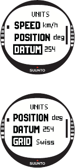
Setting the datum
The Datum setting defines the map datum you use. (For more
information on different datums and their corresponding
numbers, see the GPS Datum List appendix.)
To set the datum:
1. In the Set menu, scroll to Units and press ENTER. The
Units menu is displayed.
2. Scroll to Datum and press ENTER.
3. Select the desired datum number with UP/DOWN and
press ENTER. The datum format is now set.
Grid
The Grid setting defines the grid you use. (For more
information on different grids, see the Local Grid List
appendix.)
To set the grid:
1. In the Set menu, scroll to Units and press ENTER. The
Units menu is displayed.
2. Scroll to Grid and press ENTER.
3. Select the desired grid with UP/DOWN and press ENTER.
The grid format is now set.
3.2.6. Setting the position format
The Position setting defines the format in which position coordinates are displayed.
The setting has five options:
• deg: Degrees (second picture from the left)
• dm: Degrees and minutes (middle)
• grid: Local metric grid (second from the right, the picture displays the Swiss grid)
• utm: Global UTM (first from the right)
•mgrs: Military Grid Reference System