
Manual

MiniSLAM
SuperDroid Robots, Inc Contact
224 Technology Park Lane (919) 557-9162
Fuquay Varina, NC 27526 SDR@SDRobots.com
www.SuperDroidRobots.com
Revised: August 3, 2018 Page 6 of 13
Please take note of the following while in autonomous navigation mode:
• Avoid setting waypoints on or very close to obstacles.
• If there are no possible paths to a waypoint due to obstruction, the robot will abandon the current goal
and await new commands.
• If waypoints are sent while in manual mode, the robot will proceed with path planning but won’t act until
it enters autonomous navigation mode.
• Waypoints can be drawn in unexplored areas of the map. However, due to the computational limitations
of the BeagleBone Black, the map size is limited to 24x24 meters.
• The robot will only be able to navigate around obstacles the LIDAR can see. Any obstacles below the 2D
laser scan plane are potential collision points.
• The 2D SLAM positioning assumes a flat, indoor operating area. Sunlight and inclines/declines will result
in position drift and errors in map data.
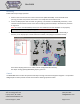
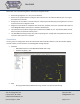
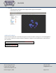
Visualization
The mini_slam.rviz configuration file comes with several data visualization features in the form of RViz displays.
This file includes, but not limited to, the following ROS message displays:
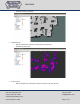
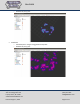
• LaserScan
o Raw LIDAR output from the YDLIDAR G4 LIDAR driver node
o Published by ydlidar_node
• Map
o 2D map generated by the SLAM node using raw laser scan data and positioning