
Manual


9
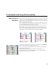
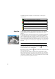
The main map can also function as an interface to collect measurements. Tap
and hold on the main map and choose Survey Mode to enable the Measurement
interface (see screen example for GNSS).
When in Survey Mode, you can collect data from the main map by tapping on
one of the available buttons (see table below).
You can also press the Enter key to trigger an observation. By default, the Enter
key will trigger a “Topo” observation. You can change the Enter key to trigger
a point observation by clearing the Survey Map Use Enter Button for Topo prompt
on the Job > Settings > Surveying tab.
Shortcut buttons are available to optimize your work. These are defined below:
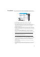
The main map view includes two additional toolbars:
• The Zoom toolbar
• The Snap-To toolbar
These are described below.
Showing /hiding the two toolbars depends on the current survey mode status.
When the survey mode is inactive:
• The Zoom toolbar is always shown.
• Tap to show the Snap-To toolbar, to hide it.
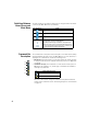
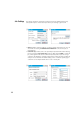
Optical Function GNSS Function
- Mechanical optical instrument: Triggers the
instrument to take a shot in the current mode (fine
or coarse).
- Robotic optical instrument: Similar to GNSS, i.e.
takes the latest tracking mode data and stores a
point.
One-epoch point measurement
- Mechanical optical instrument: Takes a fine
mode observation.
- Robotic optical instrument: Opens up the remote
control screen where you will hit the Take Shot
button to take a fine mode observation.
Multi-epoch point measurement
(static occupation)
Setting target height Setting antenna height
Station setup GNSS status