
User guide
Table Of Contents
- Software End User License Agreement
- Data Collector Warranty Program
- Table of Contents
- 1. Welcome to Survey Pro
- 2. Introduction to the Survey Pro User Interface
- 3. Creating a Job
- 4. Connecting Survey Pro to an Instrument
- 5. Optical Surveying
- 6. GNSS Surveying
- 7. Stakeout Routines
- 8. Survey Pro’s On-Board Version
- Appendix
- Index
37
This is all you need to set if your network is an Internet server for GNSS
corrections, either an NTRIP mount point, or a direct IP connection.
If the network connection is to a static IP base modem, you must also
specify the server type as Static IP Base, and select a correction format.
If you set up your own base just before, Survey Pro will automatically
choose the same correction format at the rover. If your rover supports
automatic detection of correction format, it is not necessary to specify the
correction format on this screen.
If you are using an NTRIP login page to select a mount point, Survey Pro
will automatically detect the correction format.
If you are logging into a direct IP connection use the Job > Settings >
Networks tab to specify if you want to have Survey Pro automatically detect
the correction format, or set it to a specific correction format known for that
direct IP login address.
Some GNSS receiver types can recognize the format automatically. In that
case, no format selection will be requested.
•Tap Connect.
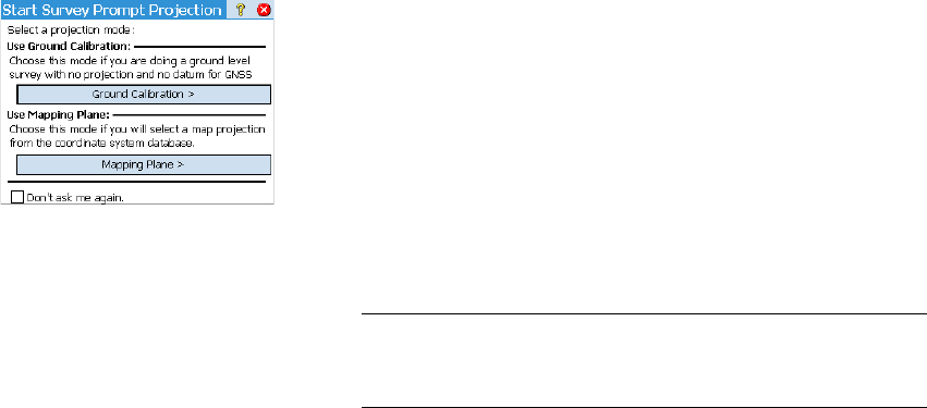
When creating a job, if you decided not to choose a coordinate system, you
will be asked to reconsider this choice when starting the survey (unless you
started your own base and you were already prompted to make a choice at
that time). The Start Survey Prompt Projection screen will appear at this time
with two possible options:
1. Ground Calibration: Choose this option if there is no known projection or
datum to relate your local grid coordinates to geodetic coordinates
(through this choice, you confirm your decision not to use any known
coordinate system). The selection of a geoid is possible after making
that choice.
2. Mapping Plane: Tap on this button if you wish to use a coordinate system
(i.e. known origin and type of projection + known datum) that can either
be keyed in or picked from Survey Pro’s coordinate system database. For
more information on the projection mode, refer to Introduction to
Calibration on page 44.
NOTE: If you always start your GNSS surveys with the same type of projection
mode, then you can tap Don't ask me again at this prompt, and Survey Pro will
start the GNSS survey with the settings you used to create the job.