
User guide
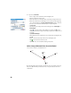
Table Of Contents
- Software End User License Agreement
- Data Collector Warranty Program
- Table of Contents
- 1. Welcome to Survey Pro
- 2. Introduction to the Survey Pro User Interface
- 3. Creating a Job
- 4. Connecting Survey Pro to an Instrument
- 5. Optical Surveying
- 6. GNSS Surveying
- 7. Stakeout Routines
- 8. Survey Pro’s On-Board Version
- Appendix
- Index

28
Alternatively, you can tap Backsight to proceed to the normal backsight
setup, with your newly calculated station point as the setup point, and your
first resection point as the backsight point. It is a good practice to do a
backsight check after a resection to ensure the instrument circle is oriented
as you expected.
When this is done, tap Finish. You can now start measuring new points.
Variants to the Basic Station Setup Procedures
There are variants to the basic step-by-step procedures described above,
related to your current job settings (in Job > Settings > Surveying tab):
• Check Setup: You may shorten the BS Azimuth and BS Point routines by
checking the Skip check during Station Setup option.
• PPM Correction: By default, the PPM will not show up in the station setup
routine. But, if you check the box for Prompt for PPM during Station Setup, the
PPM will become the first step in your station setup routine.
The PPM correction is applied to all measured slope distances. This may
be achieved in one of two different ways:
1. You enter the PPM in the instrument which in return will provide Survey
Pro with slope distances corrected for the PPM.
2. Or you enter the PPM in Survey Pro, in which case the instrument will
return uncorrected slope distances (make sure the PPM is set to “0” in
the instrument). Survey Pro will apply the PPM correction to any slope
distances that will be used in further calculations.
NOTE: With some instruments (e.g. FOCUS 30 and S6), the PPM correction can
only be set using the second method.
For any station setup, you can also set the elevation of the station point
independently using the Remote Elevation routine (see Remote Elevation on
page 29).