
Instruction Manual


set.
GRAY: Off: GeoLock is not enabled.
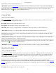
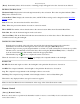
Results Card
[Survey] [Remote Control] [Results]
The Results
card displays live angle data from the total station and live distance data is displayed depending on the
current EDM mode.
[HD/VD] / [ZA/SD]: Toggles the data displayed from the total station between HA, HD and VD, or HA, ZA and SD.
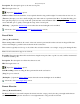
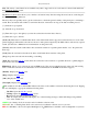
Map Card
[Survey] [Remote Control] [Map]
The Map
card displays a live map showing the total station position relative to the current foresight and backsight.
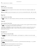
Aim Card
[Survey] [Remote Control] [Aim]
The Aim
card is used to precisely aim the instrument. Tapping around the total station graphic will turn the instrument
to the location corresponding to the horizontal and vertical scale bars.
[> By Angle] / [> By Distance]: Toggles between turning by angles or by distances, respectively. The scales in the
scale bars will also switch between angles or distances. The scales in the scale bars are calculated using the last
distance that was measured.
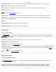
Foresight Card
[Survey] [Remote Control] [Foresight]
The Foresight
card is available only if the backsight is solved. It displays live coordinates for the current foresight.
Turn To
[Survey] [Remote Control] [Turn To]
The Turn To
screen is used to turn a robotic total station to a specified horizontal and zenith angle, or to a specified
point.
Horizontal Angle: The horizontal angle that the total station will turn to.
Zenith Angle: The zenith angle that the total station will turn to.
Survey Pro Help 5.00
88