
Instruction Manual


Inverse Menu
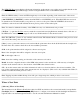
The Inverse Menu contains routines that compute the direction and distance between two objects. The following
screens are available from the Inverse Menu:
Inverse Point to Point
Inverse Point to Line
Inverse Point to Polyline
Inverse Point to Multiple Points
Inverse Point to Location / Point
Main Index
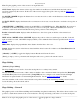
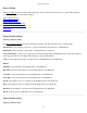
Inverse Point to Point
[Inverse] [Point to Point]
The Inverse Point to Point
screen will calculate the distance and direction between two existing points.
Begin Point: is the reference point used to compute the distance and direction to the End Point.
End Point: is the point whose relationship to the Begin Point is computed.
[Select from Map…]: allows you to quickly select both the Begin Point and End Point from a map view. The first
point tapped is entered as the Begin Point and the second as the End Point.
[Solve]: will compute the distance and direction from the Begin Point to the End Point.
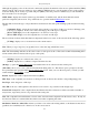
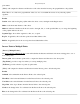
Results
Azimuth: is the azimuth from the Begin Point to the End Point.
Horz Dist: is the horizontal distance from the Begin Point to the End Point.
Vert Dist: is the vertical distance from the Begin Point to the End Point.
Slope Dist: is the slope distance from the Begin Point to the End Point.
North: is the change in the Y-coordinate from the Begin Point to the End Point.
East: is the change in the X-coordinate from the Begin Point to the End Point.
Elevation: is the change in elevation from the Begin Point to the End Point.
Grade: is the slope from the Begin Point to the End Point.
Inverse Point to Line
[Inverse] [Point to Line]
Survey Pro Help 5.00
177