
Reference Manual


Table Of Contents
- Table of Contents
- Welcome
- Main Menu
- File Menu
- Job Menu
- Job Menu – GPS
- Job Menu – Basic GPS
- Survey Menu
- Backsight Setup
- Traverse / Sideshot
- Repetition Shots
- Multiple Sideshots
- Radial Sideshots
- Distance Offset Shot
- Horizontal Angle Offset
- Vertical Angle Offset
- Auto Collect
- Corner & 2 Lines
- Corner & Angle
- Corner & Offset
- Corner & Plane
- Surface Scan
- Video Scan
- Shoot From Two Ends
- Record Mode
- Resection
- Remote Elevation
- Check Point
- Solar Observation
- Remote Control
- Survey Menu – GPS
- Survey Menu – Basic GPS
- Leveling Menu
- Stakeout Menu
- Stakeout Menu – GPS and Basic GPS
- Inverse Menu
- Cogo Menu
- Curve Menu
- Roads Menu
- Adjust Menu
- Miscelaneous Screens
- Appendix A
- Index
Job Menu
R-87
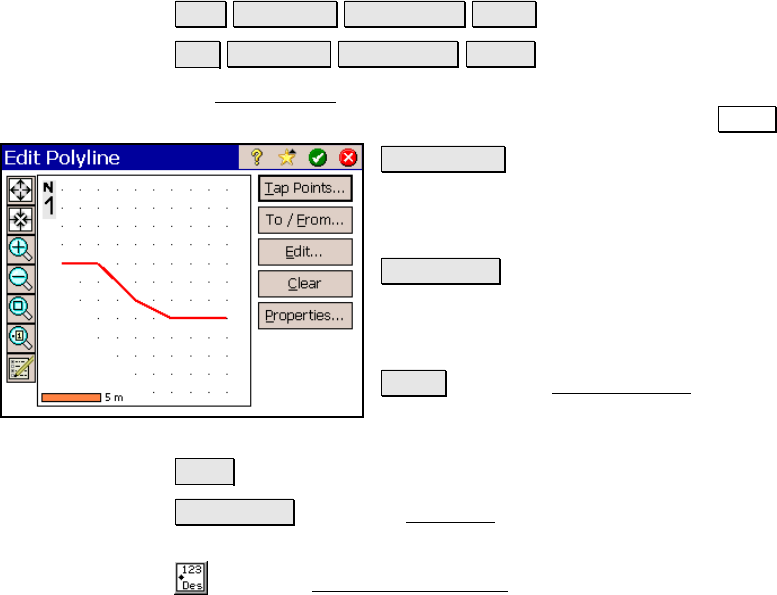
Edit Polyline
Job View DTM Breaklines… Edit… or
Job View DTM Breaklines… New….
The Edit Polyline screen is used to perform some preliminary editing
to a polyline prior to accessing the polyline editor with the Edit… key.
Tap Points… : allows you to tap points to define
a new polyline. If a polyline was already
selected prior to accessing this screen, it will be
replaced by the polyline being created.
To / From… : allows you to define a range of
points that define a polyline. If a polyline was
already selected prior to accessing this screen,
it will be replaced by the polyline being created.
Edit… : opens the Polyline Editor, described on
Page R-67, where the polyline can be further
edited.
Clear : will permanently remove the selected polyline from the job.
Properties… : opens the New Line dialog box where the description,
layer and feature attributes can be modified.
: opens the Map Display Options screen (Page R-450) to select
what is displayed on the screen.