
Reference Manual


Table Of Contents
- Table of Contents
- Welcome
- Main Menu
- File Menu
- Job Menu
- Job Menu – GPS
- Job Menu – Basic GPS
- Survey Menu
- Backsight Setup
- Traverse / Sideshot
- Repetition Shots
- Multiple Sideshots
- Radial Sideshots
- Distance Offset Shot
- Horizontal Angle Offset
- Vertical Angle Offset
- Auto Collect
- Corner & 2 Lines
- Corner & Angle
- Corner & Offset
- Corner & Plane
- Surface Scan
- Video Scan
- Shoot From Two Ends
- Record Mode
- Resection
- Remote Elevation
- Check Point
- Solar Observation
- Remote Control
- Survey Menu – GPS
- Survey Menu – Basic GPS
- Leveling Menu
- Stakeout Menu
- Stakeout Menu – GPS and Basic GPS
- Inverse Menu
- Cogo Menu
- Curve Menu
- Roads Menu
- Adjust Menu
- Miscelaneous Screens
- Appendix A
- Index
Job Menu
R-63
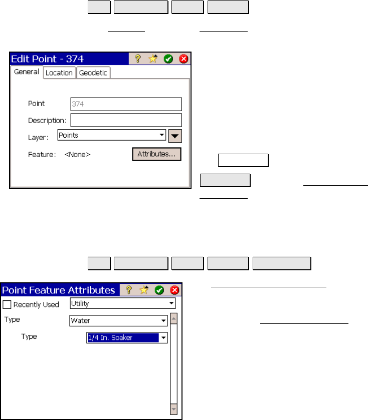
Edit Point – General
Job Edit Points Edit… General.
The General card of the Edit Point screen is used to modify the
description, layer and feature information for the selected point.
Point Name: displays the selected point’s
name.
Description: is the description for the
selected point.
Layer: is the layer for the selected point.
Feature: displays the feature assigned to the
selected point, which can be modified using
the Attributes button.
Attributes : opens the Point Feature
Attributes screen (Page R-63) where the
feature attributes for the point can be modified.
Point Feature Attributes
Job Edit Points Edit… General Attributes….
The Point Feature Attributes screen is
available from the above path or whenever a
point is stored when Prompt for Attributes is
checked in the Surveying Settings
screen (Page
R-44).
Recently Used: when ch
ecked will arrange
the order of the available features so the most
recently used features are listed first. Any
feature in the current feature file can be
selected from the corresponding drop-down list.
The content displayed in the main portion of
the window fully depends on the attribute information associated
with the selected feature.