
Reference Manual


Table Of Contents
- Table of Contents
- Welcome
- Main Menu
- File Menu
- Job Menu
- Job Menu – GPS
- Job Menu – Basic GPS
- Survey Menu
- Backsight Setup
- Traverse / Sideshot
- Repetition Shots
- Multiple Sideshots
- Radial Sideshots
- Distance Offset Shot
- Horizontal Angle Offset
- Vertical Angle Offset
- Auto Collect
- Corner & 2 Lines
- Corner & Angle
- Corner & Offset
- Corner & Plane
- Surface Scan
- Video Scan
- Shoot From Two Ends
- Record Mode
- Resection
- Remote Elevation
- Check Point
- Solar Observation
- Remote Control
- Survey Menu – GPS
- Survey Menu – Basic GPS
- Leveling Menu
- Stakeout Menu
- Stakeout Menu – GPS and Basic GPS
- Inverse Menu
- Cogo Menu
- Curve Menu
- Roads Menu
- Adjust Menu
- Miscelaneous Screens
- Appendix A
- Index
Job Menu
R-49
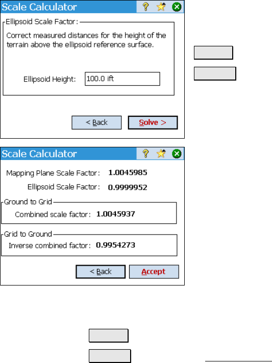
Screen Two
Ellipsoid Height: The height of the ground
above the ellipsoid surface.
< Back : returns to the previous screen.
Solve > : opens Screen Three.
Screen Three
Mapping Plane Scale Factor: displays the
scale factor that will correct for the effects of
map projection distortion.
Ellipsoid Scale Factor: displays the scale
factor to correct for the geometric effect of your
height above the ellipsoid surface.
Ground to Grid: displays the combined scale
factor that will be used for ground to grid
calculations.
Grid to Ground: displays the inverse of the combined scale factor for
grid to ground calculations.
< Back : returns to the previous screen.
Solve > : returns to the Scale Settings screen where the combined
scale factor will be entered for you.