
Reference Manual


Table Of Contents
- Table of Contents
- Welcome
- Main Menu
- File Menu
- Job Menu
- Job Menu – GPS
- Job Menu – Basic GPS
- Survey Menu
- Backsight Setup
- Traverse / Sideshot
- Repetition Shots
- Multiple Sideshots
- Radial Sideshots
- Distance Offset Shot
- Horizontal Angle Offset
- Vertical Angle Offset
- Auto Collect
- Corner & 2 Lines
- Corner & Angle
- Corner & Offset
- Corner & Plane
- Surface Scan
- Video Scan
- Shoot From Two Ends
- Record Mode
- Resection
- Remote Elevation
- Check Point
- Solar Observation
- Remote Control
- Survey Menu – GPS
- Survey Menu – Basic GPS
- Leveling Menu
- Stakeout Menu
- Stakeout Menu – GPS and Basic GPS
- Inverse Menu
- Cogo Menu
- Curve Menu
- Roads Menu
- Adjust Menu
- Miscelaneous Screens
- Appendix A
- Index
Job Menu
R-47
screen are used in determining when two shots are at the same
location.
; Survey with True Azimuths: automates the process of adjusting
the circle on the total station when traversing so that you can survey
with azimuths rather than horizontal angles (see Page R-131).
Scale Factor: displa
ys the details on the current mapping plane scale
factor, if one is configured.
Setup Scale… : access the Scale Settings screen where a mapping
plane scale factor can be configured in a variety of ways, or disabled.
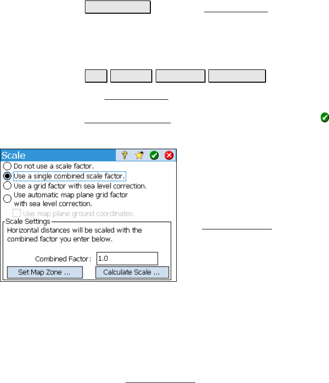
Scale Settings
Job Settings Surveying Setup Scale.
The Scale Settings screen is the starting point for setting up a
mapping grid scale factor. Once configured, you will return to the
Surveying Settings
screen where you must then tap to save the
scale settings.
Do not use a scale factor: This option will
disable any mapping plane scaling that is
currently enabled.
Use a single combined scale factor: This
uses a single combined scale factor that is
provided for you, or one can be computed with
the Calculate Scale
wizard.
Use a grid factor with sea level correction:
This option uses a mapping plane scale factor
that is adjusted for elevation changes.
Use automatic map plane grid factor with
sea level correction: This option uses a combined scale factor that is
adjusted for elevation changes.
Use map plane ground coordinates: When checked, you can
configure the job to use map plane ground coordinates.
Combined Factor: is where you enter a combined scale factor if
already known, otherwise it is the combined scale factor computed
from the Calculate Scale
wizard.