
Reference Manual


Table Of Contents
- Table of Contents
- Welcome
- Main Menu
- File Menu
- Job Menu
- Job Menu – GPS
- Job Menu – Basic GPS
- Survey Menu
- Backsight Setup
- Traverse / Sideshot
- Repetition Shots
- Multiple Sideshots
- Radial Sideshots
- Distance Offset Shot
- Horizontal Angle Offset
- Vertical Angle Offset
- Auto Collect
- Corner & 2 Lines
- Corner & Angle
- Corner & Offset
- Corner & Plane
- Surface Scan
- Video Scan
- Shoot From Two Ends
- Record Mode
- Resection
- Remote Elevation
- Check Point
- Solar Observation
- Remote Control
- Survey Menu – GPS
- Survey Menu – Basic GPS
- Leveling Menu
- Stakeout Menu
- Stakeout Menu – GPS and Basic GPS
- Inverse Menu
- Cogo Menu
- Curve Menu
- Roads Menu
- Adjust Menu
- Miscelaneous Screens
- Appendix A
- Index
Survey Pro Reference Manual
R-46
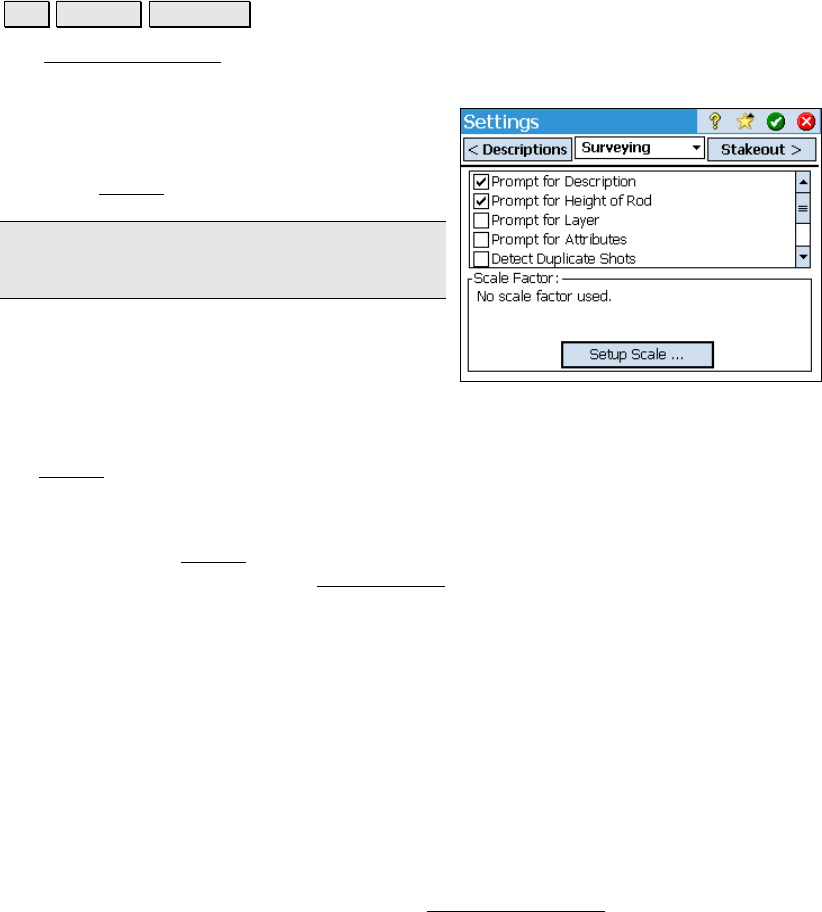
Surveying Settings
Job Settings Surveying.
The Surveying Settings card allows you to select various options that
affect how data collection is performed.
; Prompt for Description: When checked, a
prompt for a description will appear before any
new point is stored from only the routines
under the Survey
menu (Page R-121).
Note: Descriptions can be no longer than 16
characters.
; Prompt for Height of Rod: When checked,
a prompt for the rod height will appear before
any new point is stored.
; Prompt for Layer: When checked, a prompt to select a layer will
appear before any new point is stored from only the routines under
the Survey
menu (Page R-121).
; Prompt for Attributes: When checked, a prompt to select feature
information will appear before any new point is stored from only the
routines under the Survey
menu (Page R-121). This also requires that
a feature file be selected from the Files Settings
card, described
above.
; Prompt for Picture: if checked, a prompt will appear before
storing a point where you have the option of taking one or more
pictures associated with the current point. (Only available when
running on a Nomad with a digital camera.)
; Adjust for Earth Curvature / Refraction: when checked, the
elevations for new points are adjusted to compensate for the
curvature of the earth and refraction.
; Detect Duplicate Shots: When checked, a prompt will appear
before attempting to store a second shot to the same location. This
helps to catch when robotic total stations have lost lock while
surveying. The distance tolerances set in the Repetition Settings