
Reference Manual


Table Of Contents
- Table of Contents
- Welcome
- Main Menu
- File Menu
- Job Menu
- Job Menu – GPS
- Job Menu – Basic GPS
- Survey Menu
- Backsight Setup
- Traverse / Sideshot
- Repetition Shots
- Multiple Sideshots
- Radial Sideshots
- Distance Offset Shot
- Horizontal Angle Offset
- Vertical Angle Offset
- Auto Collect
- Corner & 2 Lines
- Corner & Angle
- Corner & Offset
- Corner & Plane
- Surface Scan
- Video Scan
- Shoot From Two Ends
- Record Mode
- Resection
- Remote Elevation
- Check Point
- Solar Observation
- Remote Control
- Survey Menu – GPS
- Survey Menu – Basic GPS
- Leveling Menu
- Stakeout Menu
- Stakeout Menu – GPS and Basic GPS
- Inverse Menu
- Cogo Menu
- Curve Menu
- Roads Menu
- Adjust Menu
- Miscelaneous Screens
- Appendix A
- Index
Job Menu
R-43
Coord. Order: allows you to customize the labeling and order for
coordinates used throughout the software. You can select any of the
following formats:
• N, E, Elev. (Northing, Easting, Elevation)
• X, Y, Z
• E, N, Elev. (Easting, Northing Elevation)
• Y, X, Z
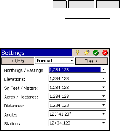
Format Settings
Job Settings Format.
The Format Settings card defines the number of places beyond the
decimal point that are displayed for various values in all screens, and
how stations are defined. (All internal calculations are performed
using full precision.)
Northings / Eastings: will allow you to display
from zero to six places passed the decimal point
for northing and easting values.
Elevations: allows you to display from zero to
six places passed the decimal point for
elevations.
Sq feet / meters: allows you to display from
zero to four places passed the decimal point for
square feet or square meter values.
Acres / Hectares: allows you to display from
zero to four places passed the decimal point for
acre or hectare values.
Distances: allows you to display from zero to six places passed the
decimal point for distances.
Angles: allows you to include from zero to four fractional seconds
with angle values.