
Reference Manual


Table Of Contents
- Table of Contents
- Welcome
- Main Menu
- File Menu
- Job Menu
- Job Menu – GPS
- Job Menu – Basic GPS
- Survey Menu
- Backsight Setup
- Traverse / Sideshot
- Repetition Shots
- Multiple Sideshots
- Radial Sideshots
- Distance Offset Shot
- Horizontal Angle Offset
- Vertical Angle Offset
- Auto Collect
- Corner & 2 Lines
- Corner & Angle
- Corner & Offset
- Corner & Plane
- Surface Scan
- Video Scan
- Shoot From Two Ends
- Record Mode
- Resection
- Remote Elevation
- Check Point
- Solar Observation
- Remote Control
- Survey Menu – GPS
- Survey Menu – Basic GPS
- Leveling Menu
- Stakeout Menu
- Stakeout Menu – GPS and Basic GPS
- Inverse Menu
- Cogo Menu
- Curve Menu
- Roads Menu
- Adjust Menu
- Miscelaneous Screens
- Appendix A
- Index
Miscellaneous Screens
R-455
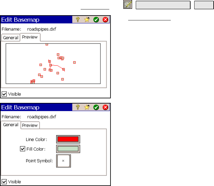
Edit Basemaps
From the Map View, tap
Manage Basemaps Edit….
The Edit Basemaps screen is used to preview
the selected basemap, and if it is a vector
basemap, the way the basemap appears can be
changed.
The Preview page shows how the selected
basemap will look in the map view.
Visible: when checked, the selected basemap
will be visible in the map view.
The General page is only available when a
vector basemap is selected and is used to
customize the way the basemap appears in the
map view.
Line Color: is used to select the line color of the
basemap.
Fill Color: is used to select the color for the 2D
objects in the basemap.
Point Symbol: is used to select from a variety
of symbols for the points in the basemap (these
will not affect the appearance of the points in
the current job).