
Reference Manual


Table Of Contents
- Table of Contents
- Welcome
- Main Menu
- File Menu
- Job Menu
- Job Menu – GPS
- Job Menu – Basic GPS
- Survey Menu
- Backsight Setup
- Traverse / Sideshot
- Repetition Shots
- Multiple Sideshots
- Radial Sideshots
- Distance Offset Shot
- Horizontal Angle Offset
- Vertical Angle Offset
- Auto Collect
- Corner & 2 Lines
- Corner & Angle
- Corner & Offset
- Corner & Plane
- Surface Scan
- Video Scan
- Shoot From Two Ends
- Record Mode
- Resection
- Remote Elevation
- Check Point
- Solar Observation
- Remote Control
- Survey Menu – GPS
- Survey Menu – Basic GPS
- Leveling Menu
- Stakeout Menu
- Stakeout Menu – GPS and Basic GPS
- Inverse Menu
- Cogo Menu
- Curve Menu
- Roads Menu
- Adjust Menu
- Miscelaneous Screens
- Appendix A
- Index
Miscellaneous Screens
R-453
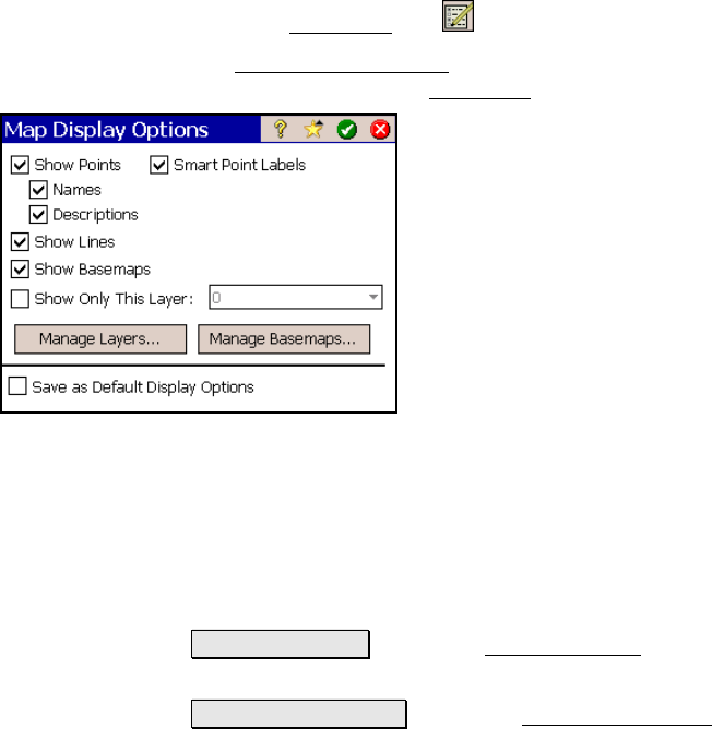
Map Display Options
From the Map View, tap
The Map Display Options
screen is used to configure the information
that is displayed in the Map View
.
Show Points: will show a dot for each point in
view.
Smart Point Labels: displays only certain
point labels (name and description) when many
points are grouped together to reduce clutter.
Names: will show the point name for each
point that is in view.
Descriptions: will show the point description
for each point in view.
Show Lines: will show all the polylines that
are on the DTM layer
Show Basemaps: will display any basemaps selected for the current
job.
Show Only This Layer: When checked, will show only the selected
point data that exists on the specified layer. When unchecked, point
data from all layers is displayed.
Manage Layers… : opens the Manage Layers screen (Page R-91)
where the layers can be configured.
Manage Basemaps... : opens the Manage Basemaps screen, described
below, where basemaps can be added to the current job.
Save as Default Display Options: When checked, will save the
selections made to this screen as the default selections.