
Reference Manual


Table Of Contents
- Table of Contents
- Welcome
- Main Menu
- File Menu
- Job Menu
- Job Menu – GPS
- Job Menu – Basic GPS
- Survey Menu
- Backsight Setup
- Traverse / Sideshot
- Repetition Shots
- Multiple Sideshots
- Radial Sideshots
- Distance Offset Shot
- Horizontal Angle Offset
- Vertical Angle Offset
- Auto Collect
- Corner & 2 Lines
- Corner & Angle
- Corner & Offset
- Corner & Plane
- Surface Scan
- Video Scan
- Shoot From Two Ends
- Record Mode
- Resection
- Remote Elevation
- Check Point
- Solar Observation
- Remote Control
- Survey Menu – GPS
- Survey Menu – Basic GPS
- Leveling Menu
- Stakeout Menu
- Stakeout Menu – GPS and Basic GPS
- Inverse Menu
- Cogo Menu
- Curve Menu
- Roads Menu
- Adjust Menu
- Miscelaneous Screens
- Appendix A
- Index
Adjust Menu
R-437
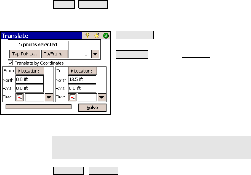
Translate
Adjust Translate.
The Translate screen will move a group a points horizontally and
vertically by a specified distance and direction.
Tap Points… : allows you to select points by
tapping them from a map view.
To/From… : Opens the Point List screen (Page
R-449) where a point list can be created.
; Translate by Coordinates: When checked,
all of the selected points will be adjusted in the
same direction and distance as between a
specified From point or location and a To point
or location. When unchecked, the selected
points will be adjusted by the specified
direction and distance. The choice made here
determines the options available below.
Note: The choice made above determines which fields will be
available below.
Azimuth / Bearing : is the direction to move the selected points.
Horizontal Distance: is the horizontal distance that the selected
points are moved.
Vertical Distance: is the vertical distance that the selected points are
moved.
From: is where the first point or location is defined that is used to
compute the direction and distance that the selected points are
adjusted.
To: is where the last point or location is defined that is used to
compute the direction and distance that the selected points are
adjusted.