
Reference Manual


Table Of Contents
- Table of Contents
- Welcome
- Main Menu
- File Menu
- Job Menu
- Job Menu – GPS
- Job Menu – Basic GPS
- Survey Menu
- Backsight Setup
- Traverse / Sideshot
- Repetition Shots
- Multiple Sideshots
- Radial Sideshots
- Distance Offset Shot
- Horizontal Angle Offset
- Vertical Angle Offset
- Auto Collect
- Corner & 2 Lines
- Corner & Angle
- Corner & Offset
- Corner & Plane
- Surface Scan
- Video Scan
- Shoot From Two Ends
- Record Mode
- Resection
- Remote Elevation
- Check Point
- Solar Observation
- Remote Control
- Survey Menu – GPS
- Survey Menu – Basic GPS
- Leveling Menu
- Stakeout Menu
- Stakeout Menu – GPS and Basic GPS
- Inverse Menu
- Cogo Menu
- Curve Menu
- Roads Menu
- Adjust Menu
- Miscelaneous Screens
- Appendix A
- Index
Survey Pro Reference Manual
R-436
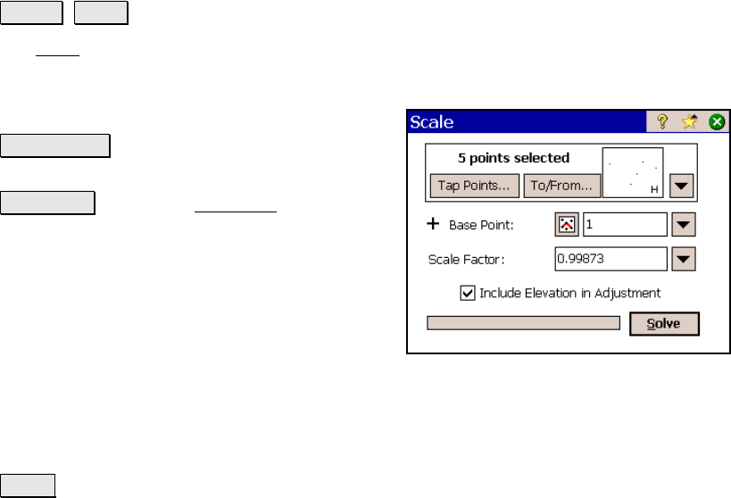
Scale
Adjust Scale.
The Scale screen will scale the distances of a range of points relative
to a specified base point. This is useful to correct a survey where a
scale factor was inadvertently applied during
data collection.
Tap Points… : allows you to select points by
tapping them from a map view.
To/From… : Opens the Point List screen (Page
R-449) where a point list can be created.
Base point: The distances to all the selected
points will be scaled relative to this point. (The
coordinates for the base point will not change.)
Scale factor: is the scale factor that is applied
to the distances from the base point to the
selected points.
; Include Elevation in Adjustment: When checked, the elevations
to the selected points will also be adjusted by the scale factor relative
to the Base point.
Solve : will perform the adjustment on the selected points and
change the coordinates accordingly. Information will be written to
the raw data file detailing the adjustment.