
Reference Manual


Table Of Contents
- Table of Contents
- Welcome
- Main Menu
- File Menu
- Job Menu
- Job Menu – GPS
- Job Menu – Basic GPS
- Survey Menu
- Backsight Setup
- Traverse / Sideshot
- Repetition Shots
- Multiple Sideshots
- Radial Sideshots
- Distance Offset Shot
- Horizontal Angle Offset
- Vertical Angle Offset
- Auto Collect
- Corner & 2 Lines
- Corner & Angle
- Corner & Offset
- Corner & Plane
- Surface Scan
- Video Scan
- Shoot From Two Ends
- Record Mode
- Resection
- Remote Elevation
- Check Point
- Solar Observation
- Remote Control
- Survey Menu – GPS
- Survey Menu – Basic GPS
- Leveling Menu
- Stakeout Menu
- Stakeout Menu – GPS and Basic GPS
- Inverse Menu
- Cogo Menu
- Curve Menu
- Roads Menu
- Adjust Menu
- Miscelaneous Screens
- Appendix A
- Index
Survey Pro Reference Manual
R-432
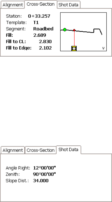
Cross-Section Card
Station: displays the station at the rod
position.
Template: displays the name of the template
that is used at the rod position.
Segment: displays the name of the template’s
segment at the rod position.
Cut / Fill: is the necessary cut or fill that will
bring the rod position even with the road’s surface.
Cut / Fill to CL: is the necessary cut or fill that will bring the rod
position to the same elevation as the centerline at the current station.
Cut / Fill to Edge: is the necessary cut or fill that will bring the rod
position to the same elevation as the outer edge of the last segment at
the current station.
Shot Data Card
Displays the angles and distance measured by
the total station from the last shot.