
Reference Manual


Table Of Contents
- Table of Contents
- Welcome
- Main Menu
- File Menu
- Job Menu
- Job Menu – GPS
- Job Menu – Basic GPS
- Survey Menu
- Backsight Setup
- Traverse / Sideshot
- Repetition Shots
- Multiple Sideshots
- Radial Sideshots
- Distance Offset Shot
- Horizontal Angle Offset
- Vertical Angle Offset
- Auto Collect
- Corner & 2 Lines
- Corner & Angle
- Corner & Offset
- Corner & Plane
- Surface Scan
- Video Scan
- Shoot From Two Ends
- Record Mode
- Resection
- Remote Elevation
- Check Point
- Solar Observation
- Remote Control
- Survey Menu – GPS
- Survey Menu – Basic GPS
- Leveling Menu
- Stakeout Menu
- Stakeout Menu – GPS and Basic GPS
- Inverse Menu
- Cogo Menu
- Curve Menu
- Roads Menu
- Adjust Menu
- Miscelaneous Screens
- Appendix A
- Index
Roads Menu
R-431
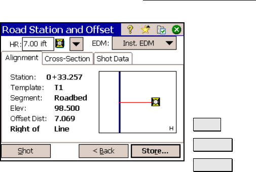
Road Station and Offset – Screen
Two
The second Road Station and Offset screen is used to take a shot to
the prism and view the data from various cards.
Height of Rod: is the length of the rod.
EDM: This button can be toggled to shoot in
various EDM modes. The options available
depend on the total station being used.
Consult the total station’s documentation for
more information on the EDM modes that it
supports.
Shot : takes a shot to the prism.
< Back : returns to the previous screen.
Store… : stores the stake point.
Alignment Card
Station: displays the station at the rod position.
Template: displays the name of the template that is used at the rod
position.
Segment: displays the name of the template’s segment at the rod
position.
Elev: displays the elevation at the rod position.
Offset Dist: displays the perpendicular offset from the centerline to
the rod position.
Right of Line / Left of Line / On Line: displays if the rod position is
to the right of the centerline, left of the centerline, or on the
centerline, respectively.