
Reference Manual


Table Of Contents
- Table of Contents
- Welcome
- Main Menu
- File Menu
- Job Menu
- Job Menu – GPS
- Job Menu – Basic GPS
- Survey Menu
- Backsight Setup
- Traverse / Sideshot
- Repetition Shots
- Multiple Sideshots
- Radial Sideshots
- Distance Offset Shot
- Horizontal Angle Offset
- Vertical Angle Offset
- Auto Collect
- Corner & 2 Lines
- Corner & Angle
- Corner & Offset
- Corner & Plane
- Surface Scan
- Video Scan
- Shoot From Two Ends
- Record Mode
- Resection
- Remote Elevation
- Check Point
- Solar Observation
- Remote Control
- Survey Menu – GPS
- Survey Menu – Basic GPS
- Leveling Menu
- Stakeout Menu
- Stakeout Menu – GPS and Basic GPS
- Inverse Menu
- Cogo Menu
- Curve Menu
- Roads Menu
- Adjust Menu
- Miscelaneous Screens
- Appendix A
- Index
Survey Pro Reference Manual
R-430
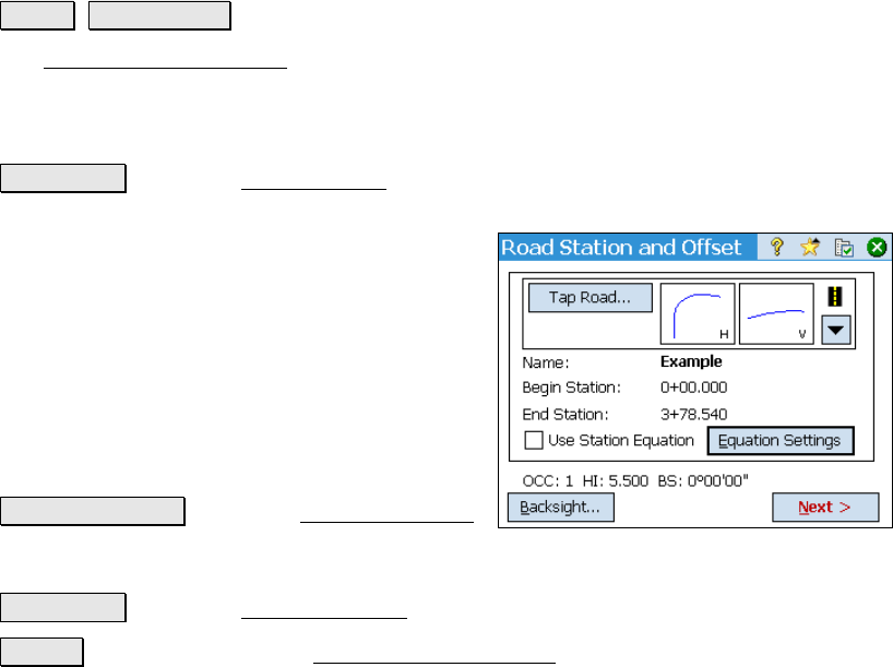
Road Station and Offset
Roads Show Station.
The Road Station and Offset routine allows you to take a shot to a
prism that is positioned anywhere on the road and compute the
details of where that point is located in relation to the road. This
information can then be compared to the data from a grade sheet.
Tap Road… : opens the Tap on a Road screen where you can tap on
any road in the job to select it.
Name: displays the name of the selected road.
Begin Station: displays the station assigned to
the beginning of the road.
End Station: displays the final station in the
road.
Use Station Equation: When checked, the
current station equation will be applied to the
road.
Equation Settings : opens the Station Equation
screen (Page R-433) where a station equation
can be configured.
Backsight… : opens the Backsight Setup screen (Page R-122).
Next > : takes you to the next Road Station and Offset screen where
the slope staking parameters are set up.