
Reference Manual


Table Of Contents
- Table of Contents
- Welcome
- Main Menu
- File Menu
- Job Menu
- Job Menu – GPS
- Job Menu – Basic GPS
- Survey Menu
- Backsight Setup
- Traverse / Sideshot
- Repetition Shots
- Multiple Sideshots
- Radial Sideshots
- Distance Offset Shot
- Horizontal Angle Offset
- Vertical Angle Offset
- Auto Collect
- Corner & 2 Lines
- Corner & Angle
- Corner & Offset
- Corner & Plane
- Surface Scan
- Video Scan
- Shoot From Two Ends
- Record Mode
- Resection
- Remote Elevation
- Check Point
- Solar Observation
- Remote Control
- Survey Menu – GPS
- Survey Menu – Basic GPS
- Leveling Menu
- Stakeout Menu
- Stakeout Menu – GPS and Basic GPS
- Inverse Menu
- Cogo Menu
- Curve Menu
- Roads Menu
- Adjust Menu
- Miscelaneous Screens
- Appendix A
- Index
Roads Menu
R-413
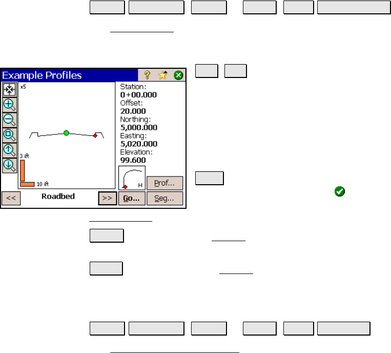
Road Profiles Screen
Roads Edit Roads ( New… or Edit… ) Road View Profiles….
The Road Profiles screen allows you to see information about the
cross-sectional profile of the road at any station after at least one
template has been added to each side of the road.
<< , >> : these buttons move a red circle
icon that starts at the centerline, which is
indicated by a green circle, to each node of the
template at the current station. Information
for the selected segment is displayed in the
right portion of the screen. The name for the
selected segment is shown between these
buttons.
Go… : opens a dialog box where a specific
station can be entered. Once is tapped, the
profile at the entered location is shown in the
Road Profiles
screen.
Prof… : opens the profile Details screen and lists several details
about the road’s cross-sectional profile at the current station.
Seg… : opens the segment Details screen and lists information
related to the selected segment at the current station.
Road Alignment Properties Screen
Roads Edit Roads ( New… or Edit… ) Road Set POB….
The Road Alignment Properties screen is used to change information
about the current alignment.