
Reference Manual


Table Of Contents
- Table of Contents
- Welcome
- Main Menu
- File Menu
- Job Menu
- Job Menu – GPS
- Job Menu – Basic GPS
- Survey Menu
- Backsight Setup
- Traverse / Sideshot
- Repetition Shots
- Multiple Sideshots
- Radial Sideshots
- Distance Offset Shot
- Horizontal Angle Offset
- Vertical Angle Offset
- Auto Collect
- Corner & 2 Lines
- Corner & Angle
- Corner & Offset
- Corner & Plane
- Surface Scan
- Video Scan
- Shoot From Two Ends
- Record Mode
- Resection
- Remote Elevation
- Check Point
- Solar Observation
- Remote Control
- Survey Menu – GPS
- Survey Menu – Basic GPS
- Leveling Menu
- Stakeout Menu
- Stakeout Menu – GPS and Basic GPS
- Inverse Menu
- Cogo Menu
- Curve Menu
- Roads Menu
- Adjust Menu
- Miscelaneous Screens
- Appendix A
- Index
Roads Menu
R-411
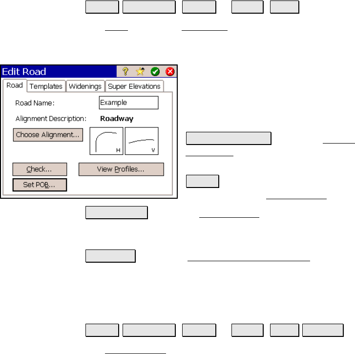
The Road Card
Roads Edit Roads ( New… or Edit… ) Road.
The Road card of the New Road screen is used to select the alignment
to use for the road. If an alignment has not yet been created, refer to
Page R-70 for information on creating an alignment.
Road Name: is the
name assigned to the road.
The name must not be the same as any existing
road name.
Alignment Description: displays the name of
the selected alignment.
Choose Alignment : opens the Choose
Alignment screen where an existing alignment
can be selected.
Check : checks the road for errors and displays
the results in the Roads Report screen.
View Profiles : opens the Road Profiles screen where you can see
information about the cross-sectional profile of the road at any
station.
Set POB… : opens the Road Alignment Properties screen where
information about the current alignment can be changed.
Roads Report Screen
Roads Edit Roads ( New… or Edit… ) Road Check….
The Roads Report screen displays a list of any errors after performing
the following tests.
• Confirm that the alignment contains both a HAL and a VAL.
• Confirm that the horizontal length of the VAL is greater than
or equal to the HAL.
• Confirm there is at least one template for each side of the
road.