
Reference Manual


Table Of Contents
- Table of Contents
- Welcome
- Main Menu
- File Menu
- Job Menu
- Job Menu – GPS
- Job Menu – Basic GPS
- Survey Menu
- Backsight Setup
- Traverse / Sideshot
- Repetition Shots
- Multiple Sideshots
- Radial Sideshots
- Distance Offset Shot
- Horizontal Angle Offset
- Vertical Angle Offset
- Auto Collect
- Corner & 2 Lines
- Corner & Angle
- Corner & Offset
- Corner & Plane
- Surface Scan
- Video Scan
- Shoot From Two Ends
- Record Mode
- Resection
- Remote Elevation
- Check Point
- Solar Observation
- Remote Control
- Survey Menu – GPS
- Survey Menu – Basic GPS
- Leveling Menu
- Stakeout Menu
- Stakeout Menu – GPS and Basic GPS
- Inverse Menu
- Cogo Menu
- Curve Menu
- Roads Menu
- Adjust Menu
- Miscelaneous Screens
- Appendix A
- Index
Survey Pro Reference Manual
R-400
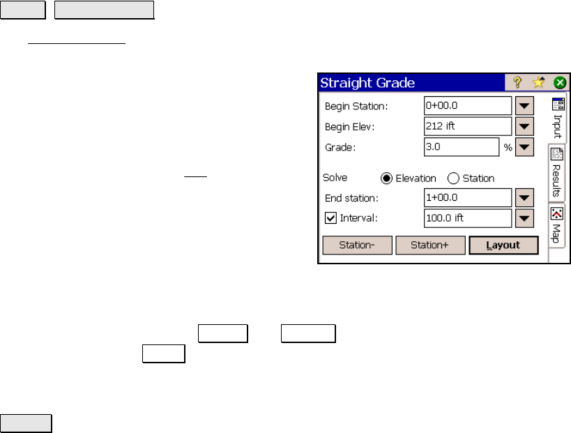
Straight Grade
Curve Straight Grade.
The Straight Grade screen will solve for the elevation at a specified
station or a station at a specified elevation on a straight grade.
Begin Station: is the station where the
straight grade begins.
Begin Elev: is the elevation at the Begin
station.
Grade: is the percent slope (
100
Run
Rise
⋅ ).
Solve for: is where you select to solve for an
Elevation or a Station. The choice made here
determines which of the following selections
are available.
End station: is the station where you want to compute the elevation.
; Interval: When checked, the End station can be incremented by the
specified interval by using the Station- and Station+ buttons and then
re-computed with the Layout button.
End Elevation: is the elevation at the point where you want to
compute the station.
Layout : performs the computation and displays the results.
Results
Station: is the current station.
Elevation: is the elevation for the current station.