
Reference Manual


Table Of Contents
- Table of Contents
- Welcome
- Main Menu
- File Menu
- Job Menu
- Job Menu – GPS
- Job Menu – Basic GPS
- Survey Menu
- Backsight Setup
- Traverse / Sideshot
- Repetition Shots
- Multiple Sideshots
- Radial Sideshots
- Distance Offset Shot
- Horizontal Angle Offset
- Vertical Angle Offset
- Auto Collect
- Corner & 2 Lines
- Corner & Angle
- Corner & Offset
- Corner & Plane
- Surface Scan
- Video Scan
- Shoot From Two Ends
- Record Mode
- Resection
- Remote Elevation
- Check Point
- Solar Observation
- Remote Control
- Survey Menu – GPS
- Survey Menu – Basic GPS
- Leveling Menu
- Stakeout Menu
- Stakeout Menu – GPS and Basic GPS
- Inverse Menu
- Cogo Menu
- Curve Menu
- Roads Menu
- Adjust Menu
- Miscelaneous Screens
- Appendix A
- Index
Survey Pro Reference Manual
R-376
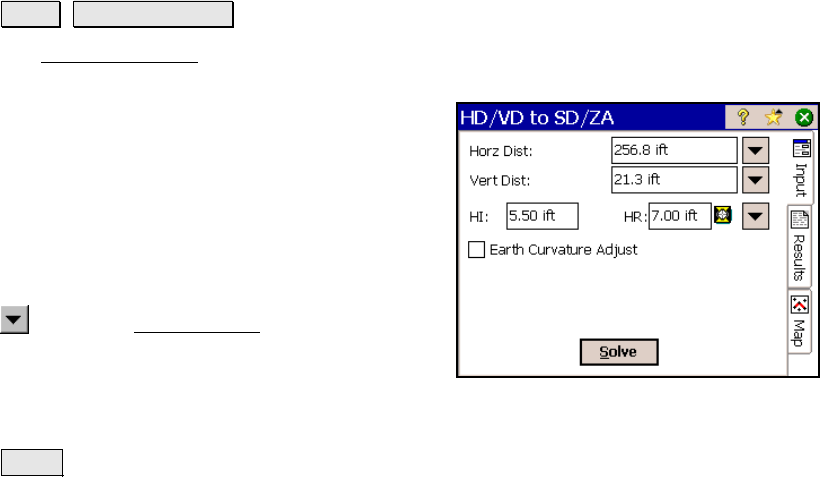
HD/VD to SD/ZA
Cogo HD/VD to SD/ZA.
The HD/VD to SD/ZA screen will convert a vertical and horizontal
distance to an equivalent slope distance and zenith angle.
Horz Dist: is the horizontal distance from the
occupy point to the foresight point.
Vert Dist: is the vertical distance from the
occupy point to the foresight point.
HI: is the distance that the total station is
above the ground.
HR: is the length of the rod.
: opens the Smart Target options (Page R-
456).
; Earth Cur
vature Adjust: When checked, the
resulting zenith angle and slope distance will account for the
curvature of the earth and refraction.
Solve : computes the equivalent slope distance and zenith angle from
the data entered.
Results
Zenith: is the computed zenith angle from the occupy point to the
foresight point.
Slope Dist: is the computed slope distance from the occupy point to
the foresight point.