
Reference Manual


Table Of Contents
- Table of Contents
- Welcome
- Main Menu
- File Menu
- Job Menu
- Job Menu – GPS
- Job Menu – Basic GPS
- Survey Menu
- Backsight Setup
- Traverse / Sideshot
- Repetition Shots
- Multiple Sideshots
- Radial Sideshots
- Distance Offset Shot
- Horizontal Angle Offset
- Vertical Angle Offset
- Auto Collect
- Corner & 2 Lines
- Corner & Angle
- Corner & Offset
- Corner & Plane
- Surface Scan
- Video Scan
- Shoot From Two Ends
- Record Mode
- Resection
- Remote Elevation
- Check Point
- Solar Observation
- Remote Control
- Survey Menu – GPS
- Survey Menu – Basic GPS
- Leveling Menu
- Stakeout Menu
- Stakeout Menu – GPS and Basic GPS
- Inverse Menu
- Cogo Menu
- Curve Menu
- Roads Menu
- Adjust Menu
- Miscelaneous Screens
- Appendix A
- Index
Cogo Menu
R-375
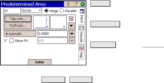
Editor… : opens the Polyline Editor (Page R-
67) where a new polyline can be created or an
existing polyline can be modified.
Tap Points… : provides a map view where you
can tap any existing points to define the fixed
sides of the boundary.
To/From… : Opens the Point List screen (Page
R-449) where a point list can be created.
; Store Pt 1 / 2: When checked, will store a
point at the location of the end point(s) of the
computed boundary line.
Azimuth / Bearing : defines the direction of the boundary sides
with lengths that are not yet known.
Results
Point 1 / 2: Displays the coordinate of the end points of the computed
boundary line.
Total Area: is the total area of the boundary.
Plot Area: is the area enclosed by the pre-defined fixed boundary
lines.
Difference: is the difference between the Total Area and the Plot Area.