
Reference Manual


Table Of Contents
- Table of Contents
- Welcome
- Main Menu
- File Menu
- Job Menu
- Job Menu – GPS
- Job Menu – Basic GPS
- Survey Menu
- Backsight Setup
- Traverse / Sideshot
- Repetition Shots
- Multiple Sideshots
- Radial Sideshots
- Distance Offset Shot
- Horizontal Angle Offset
- Vertical Angle Offset
- Auto Collect
- Corner & 2 Lines
- Corner & Angle
- Corner & Offset
- Corner & Plane
- Surface Scan
- Video Scan
- Shoot From Two Ends
- Record Mode
- Resection
- Remote Elevation
- Check Point
- Solar Observation
- Remote Control
- Survey Menu – GPS
- Survey Menu – Basic GPS
- Leveling Menu
- Stakeout Menu
- Stakeout Menu – GPS and Basic GPS
- Inverse Menu
- Cogo Menu
- Curve Menu
- Roads Menu
- Adjust Menu
- Miscelaneous Screens
- Appendix A
- Index
Survey Pro Reference Manual
R-374
Predetermined Area
Cogo Predetermined Area.
The Predetermined Area routine will take a boundary with one
open side and compute the location of a line that will enclose the
boundary with a specified area using the Hinge Method or the
Parallel Method.
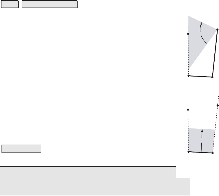
The Hinge Method computes the location of the side of a
boundary that can pivot on a fixed point.
The Parallel Method computes the location of one side of a four-
sided boundary where the computed side is parallel to a
stationary side of the boundary.
The top-left field is used to enter the desired area of the
specified boundary. In the next field, select the units entered
from the dropdown list.
Hinge: solves the boundary using the Hinge Method when
selected.
Parallel: solves the boundary using the Parallel Method when
selected.
Tap Polyline… : allows you to tap an existing polyline from a
map view to define the fixed sides of the boundary.
Note: a boundary has two fixed sides and one side defined by a
direction when using the Hinge Method. It has one fixed side and two
sides defined by a direction when using the Parallel Method.
32
1
4 (hinge)
?
Hinge Method
32
?
1
4
Parallel Method