
Reference Manual


Table Of Contents
- Table of Contents
- Welcome
- Main Menu
- File Menu
- Job Menu
- Job Menu – GPS
- Job Menu – Basic GPS
- Survey Menu
- Backsight Setup
- Traverse / Sideshot
- Repetition Shots
- Multiple Sideshots
- Radial Sideshots
- Distance Offset Shot
- Horizontal Angle Offset
- Vertical Angle Offset
- Auto Collect
- Corner & 2 Lines
- Corner & Angle
- Corner & Offset
- Corner & Plane
- Surface Scan
- Video Scan
- Shoot From Two Ends
- Record Mode
- Resection
- Remote Elevation
- Check Point
- Solar Observation
- Remote Control
- Survey Menu – GPS
- Survey Menu – Basic GPS
- Leveling Menu
- Stakeout Menu
- Stakeout Menu – GPS and Basic GPS
- Inverse Menu
- Cogo Menu
- Curve Menu
- Roads Menu
- Adjust Menu
- Miscelaneous Screens
- Appendix A
- Index
Cogo Menu
R-371
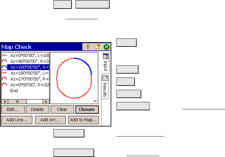
Map Check
Cogo Map Check.
The Map Check screen is used to manually enter boundaries from a
map to check for closure and other information related to the
boundary.
Edit… : opens the appropriate editor screen
where you can edit the selected line or curve
from the list.
Delete : deletes the selected line segment.
Clear : clears all line entries.
Closure : opens the Results page.
Add Line… : opens the Add / Edit Line screen,
(Page R-372), where a new line can be added
prior to the select segment.
Add Arc… : opens the Add / Edit Curve screen (Page R-372) where a
new curve can be added prior to the selected segment.
Add to Map… : opens the Add to Map screen (Page R-373) where the
map data entered in the list can be added to the current job as a
polyline.
Results
Area: is the area that the boundary encloses. If the start and end
points are in different locations, the area is computed as if a line
joined these two points.
Length: is the length of the boundary from the first point to the last
point.
Perimeter: is the length of the boundary from the first point to the
last point, plus any additional length between the last point and the
first point.