
Reference Manual


Table Of Contents
- Table of Contents
- Welcome
- Main Menu
- File Menu
- Job Menu
- Job Menu – GPS
- Job Menu – Basic GPS
- Survey Menu
- Backsight Setup
- Traverse / Sideshot
- Repetition Shots
- Multiple Sideshots
- Radial Sideshots
- Distance Offset Shot
- Horizontal Angle Offset
- Vertical Angle Offset
- Auto Collect
- Corner & 2 Lines
- Corner & Angle
- Corner & Offset
- Corner & Plane
- Surface Scan
- Video Scan
- Shoot From Two Ends
- Record Mode
- Resection
- Remote Elevation
- Check Point
- Solar Observation
- Remote Control
- Survey Menu – GPS
- Survey Menu – Basic GPS
- Leveling Menu
- Stakeout Menu
- Stakeout Menu – GPS and Basic GPS
- Inverse Menu
- Cogo Menu
- Curve Menu
- Roads Menu
- Adjust Menu
- Miscelaneous Screens
- Appendix A
- Index
Cogo Menu
R-369
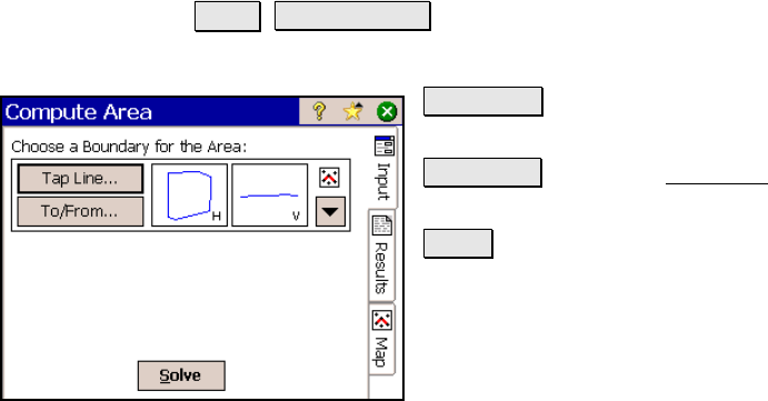
Compute Area
Cogo Compute Area.
Allows you to compute the area of a selected boundary.
Tap Line… : allows you to tap an existing
polyline from a map view.
To/From… : Opens the Point List screen (Page
R-449) where a point list can be created.
Solve : will compute the area of the selected
boundary.
Results
Area: is the area that the boundary encloses. If the boundary is not
closed, the area is computed as if a line joined the two ends.
Length: is the length of the selected boundary.
Perimeter: is the length of the selected boundary, plus any additional
length between the two ends of an open boundary.