
Reference Manual


Table Of Contents
- Table of Contents
- Welcome
- Main Menu
- File Menu
- Job Menu
- Job Menu – GPS
- Job Menu – Basic GPS
- Survey Menu
- Backsight Setup
- Traverse / Sideshot
- Repetition Shots
- Multiple Sideshots
- Radial Sideshots
- Distance Offset Shot
- Horizontal Angle Offset
- Vertical Angle Offset
- Auto Collect
- Corner & 2 Lines
- Corner & Angle
- Corner & Offset
- Corner & Plane
- Surface Scan
- Video Scan
- Shoot From Two Ends
- Record Mode
- Resection
- Remote Elevation
- Check Point
- Solar Observation
- Remote Control
- Survey Menu – GPS
- Survey Menu – Basic GPS
- Leveling Menu
- Stakeout Menu
- Stakeout Menu – GPS and Basic GPS
- Inverse Menu
- Cogo Menu
- Curve Menu
- Roads Menu
- Adjust Menu
- Miscelaneous Screens
- Appendix A
- Index
Survey Pro Reference Manual
R-366
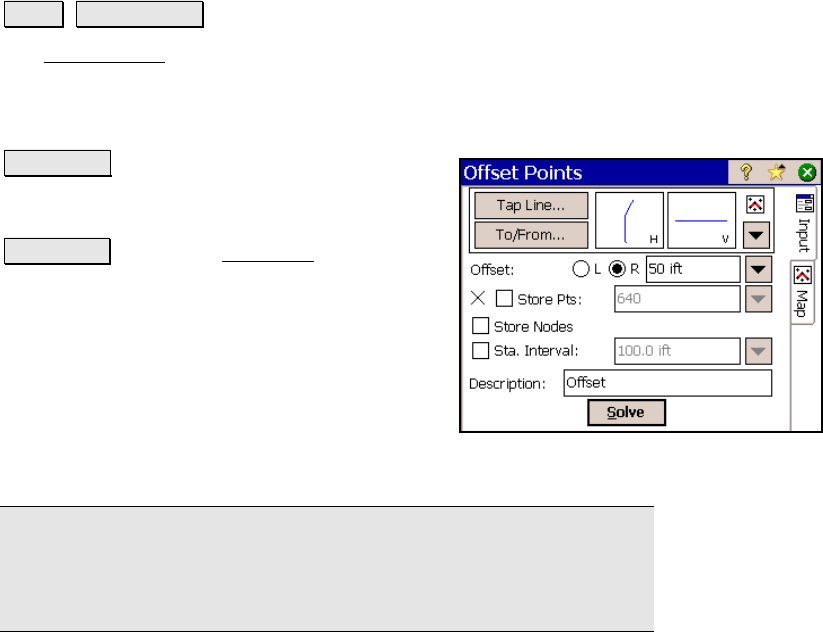
Offset Points
Cogo Offset Points.
The Offset Points screen is used to store points at a specified
perpendicular offset to an existing polyline, alignment, or point
range. Points can be stored that correspond with the nodes of an
alignment, points of a polyline, and/or at a specified station interval.
Tap Line… : allows you to tap an existing
polyline or alignment that the offset points will
be computed from.
To/From… : Opens the Point List screen (Page
R-449) where a point list can be created.
Offset: defines the offset distance and which
side the offset occurs. The right or left side is
referenced from the first point that defines the
selected line.
; Store Pts: When checked, will store the
offset points that are computed based on the selected line and which
of the two following checkboxes are checked.
Note: Leaving the Store Pts field unchecked and solving the screen
will result in a map screen that displays the points that would be
stored, but without actually storing anything to the job. This is
useful for testing the routine before storing information.
; Store Nodes: When checked, computes offset points that
correspond to each node in the selected alignment (points where the
horizontal or vertical alignment change), or that correspond to the
existing points in a selected line or point range.
; Sta. Intervals: When checked, computes offset points from the
beginning of the selected line or point range, and at each specified
station interval along the line or point range.
Description: is the description that will be assigned to all points that
are stored.